
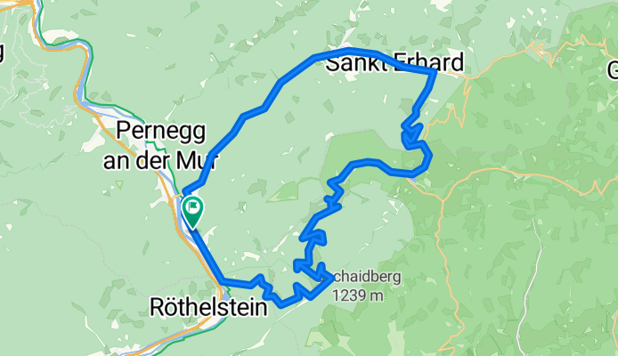
ALPENTOUR-DRACHENTOUR
A cycling route starting in Röthelstein, Styria, Austria.
Overview
About this route
Namensgeber für diese Tour ist die sagenumwobene Drachenhöhle im Grazer Bergland. Höhepunkte auf dieser Rundtour sind sicherlich die Tyrnauer Alm im Naturpark Almenland, die einen wunderbaren Rundblick auf die Umgebung bietet wie auch die teils rasanten Abfahrten hinunter ins Murtal.
- -:--
- Duration
- 42 km
- Distance
- 1,161 m
- Ascent
- 1,161 m
- Descent
- ---
- Avg. speed
- ---
- Avg. speed

Route quality
Waytypes & surfaces along the route
Waytypes
Track
17.7 km
(42 %)
Busy road
13.6 km
(32 %)
Surfaces
Paved
6.8 km
(16 %)
Unpaved
17.6 km
(42 %)
Gravel
9.4 km
(22 %)
Unpaved (undefined)
7.4 km
(18 %)
Continue with Bikemap
Use, edit, or download this cycling route
You would like to ride ALPENTOUR-DRACHENTOUR or customize it for your own trip? Here is what you can do with this Bikemap route:
Free features
- Save this route as favorite or in collections
- Copy & plan your own version of this route
- Sync your route with Garmin or Wahoo
Premium features
Free trial for 3 days, or one-time payment. More about Bikemap Premium.
- Navigate this route on iOS & Android
- Export a GPX / KML file of this route
- Create your custom printout (try it for free)
- Download this route for offline navigation
Discover more Premium features.
Get Bikemap PremiumFrom our community
Other popular routes starting in Röthelstein
- Drachentour
- Distance
- 42 km
- Ascent
- 1,161 m
- Descent
- 1,161 m
- Location
- Röthelstein, Styria, Austria
 Bärenschützklamm + Hochlantsch
- Distance
- 22.4 km
- Ascent
- 1,301 m
- Descent
- 1,301 m
- Location
- Röthelstein, Styria, Austria
 Teichalmrunde Steiermark
- Distance
- 16.8 km
- Ascent
- 654 m
- Descent
- 672 m
- Location
- Röthelstein, Styria, Austria
 Drachentour
- Distance
- 42 km
- Ascent
- 1,161 m
- Descent
- 1,164 m
- Location
- Röthelstein, Styria, Austria
 Drachentour
- Distance
- 41.6 km
- Ascent
- 1,190 m
- Descent
- 1,190 m
- Location
- Röthelstein, Styria, Austria
 Drachentour (neu)
- Distance
- 41.9 km
- Ascent
- 1,198 m
- Descent
- 1,198 m
- Location
- Röthelstein, Styria, Austria
 teichalm tour
- Distance
- 38.5 km
- Ascent
- 1,124 m
- Descent
- 1,121 m
- Location
- Röthelstein, Styria, Austria
 Route nach Teichalm 42a
- Distance
- 82.8 km
- Ascent
- 8,567 m
- Descent
- 8,565 m
- Location
- Röthelstein, Styria, Austria

Open it in the app