

020 - 2014
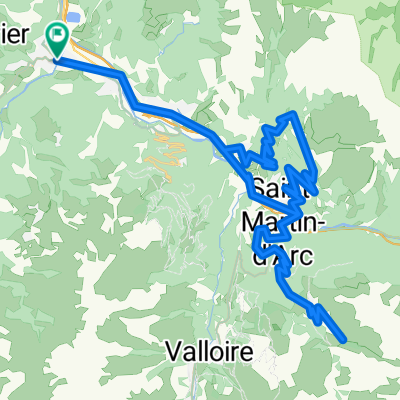
A cycling route starting in Saint-Jean-de-Maurienne, Auvergne-Rhône-Alpes, France.
Overview
About this route
20 dzień wyprawy rowerowej Italia & Alpy 2014
z Saint-Jean-de-Maurine do Bonneval-sr-Arc Col de la Madeleine 1746 n.p.m.- -:--
- Duration
- 71.8 km
- Distance
- 1,404 m
- Ascent
- 178 m
- Descent
- ---
- Avg. speed
- ---
- Max. altitude

Route quality
Waytypes & surfaces along the route
Waytypes
Road
4.3 km
(6 %)
Quiet road
2.2 km
(3 %)
Surfaces
Paved
66 km
(92 %)
Unpaved
0.7 km
(1 %)
Asphalt
66 km
(92 %)
Gravel
0.7 km
(1 %)
Undefined
5 km
(7 %)
Route highlights
Points of interest along the route

Point of interest after 60.7 km
11.07.2014 Col de la Madeleine 1746 m n.p.m.

Point of interest after 71.7 km
11.07.2014 Biwak na dziko w Bonneval-sur-Arc
Continue with Bikemap
Use, edit, or download this cycling route
You would like to ride 020 - 2014 or customize it for your own trip? Here is what you can do with this Bikemap route:
Free features
- Save this route as favorite or in collections
- Copy & plan your own version of this route
- Sync your route with Garmin or Wahoo
Premium features
Free trial for 3 days, or one-time payment. More about Bikemap Premium.
- Navigate this route on iOS & Android
- Export a GPX / KML file of this route
- Create your custom printout (try it for free)
- Download this route for offline navigation
Discover more Premium features.
Get Bikemap PremiumFrom our community
Other popular routes starting in Saint-Jean-de-Maurienne
 Etape intermédiaire CFJ Tour 2021 Montvernier
- Distance
- 47.5 km
- Ascent
- 1,159 m
- Descent
- 1,227 m
- Location
- Saint-Jean-de-Maurienne, Auvergne-Rhône-Alpes, France
 Maurienne - J3
- Distance
- 164.2 km
- Ascent
- 3,430 m
- Descent
- 3,429 m
- Location
- Saint-Jean-de-Maurienne, Auvergne-Rhône-Alpes, France
 Maurienne - J4
- Distance
- 76.9 km
- Ascent
- 2,005 m
- Descent
- 2,005 m
- Location
- Saint-Jean-de-Maurienne, Auvergne-Rhône-Alpes, France
 Col de la Croix de Fer- Col du Glandon
- Distance
- 62.3 km
- Ascent
- 1,665 m
- Descent
- 1,665 m
- Location
- Saint-Jean-de-Maurienne, Auvergne-Rhône-Alpes, France
 Subidas a los Cols de Glandon-Croix de Fer y de la Madeleine
- Distance
- 132.6 km
- Ascent
- 3,278 m
- Descent
- 3,285 m
- Location
- Saint-Jean-de-Maurienne, Auvergne-Rhône-Alpes, France
 chaussy
- Distance
- 67.8 km
- Ascent
- 2,279 m
- Descent
- 2,290 m
- Location
- Saint-Jean-de-Maurienne, Auvergne-Rhône-Alpes, France
 montée oullaz par jarrier 002
- Distance
- 12.8 km
- Ascent
- 1,016 m
- Descent
- 30 m
- Location
- Saint-Jean-de-Maurienne, Auvergne-Rhône-Alpes, France
 020 - 2014
- Distance
- 71.8 km
- Ascent
- 1,404 m
- Descent
- 178 m
- Location
- Saint-Jean-de-Maurienne, Auvergne-Rhône-Alpes, France
Open it in the app