

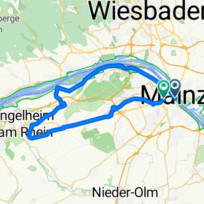
De: Mainz Süd süss
A cycling route starting in Mainz, Rhineland-Palatinate, Germany.
Overview
About this route
From Mainz to the hills of Rhineland-Palatinate (Ober-Olm, Nieder-Olm) and Nierstein. Along the Rhine and back through the vineyards.
- -:--
- Duration
- 54.9 km
- Distance
- 568 m
- Ascent
- 555 m
- Descent
- ---
- Avg. speed
- 244 m
- Max. altitude
Route quality
Waytypes & surfaces along the route
Waytypes
Road
20.8 km
(38 %)
Track
7.7 km
(14 %)
Surfaces
Paved
48.8 km
(89 %)
Unpaved
0.5 km
(1 %)
Asphalt
48.8 km
(89 %)
Ground
0.5 km
(1 %)
Undefined
5.5 km
(10 %)
Continue with Bikemap
Use, edit, or download this cycling route
You would like to ride De: Mainz Süd süss or customize it for your own trip? Here is what you can do with this Bikemap route:
Free features
- Save this route as favorite or in collections
- Copy & plan your own version of this route
- Sync your route with Garmin or Wahoo
Premium features
Free trial for 3 days, or one-time payment. More about Bikemap Premium.
- Navigate this route on iOS & Android
- Export a GPX / KML file of this route
- Create your custom printout (try it for free)
- Download this route for offline navigation
Discover more Premium features.
Get Bikemap PremiumFrom our community
Other popular routes starting in Mainz
 31_Mainz – Heidesheim – Ingelheim – Gonsenheim – Mainz
- Distance
- 40.5 km
- Ascent
- 227 m
- Descent
- 213 m
- Location
- Mainz, Rhineland-Palatinate, Germany
 20190824 Schoppingroute
- Distance
- 15.7 km
- Ascent
- 72 m
- Descent
- 71 m
- Location
- Mainz, Rhineland-Palatinate, Germany
 Mainz Ingelheim-Nord Oestrich-winkel
- Distance
- 46.8 km
- Ascent
- 62 m
- Descent
- 60 m
- Location
- Mainz, Rhineland-Palatinate, Germany
 Runde über Lörzweiler
- Distance
- 34.5 km
- Ascent
- 241 m
- Descent
- 238 m
- Location
- Mainz, Rhineland-Palatinate, Germany
 Kleiner Rundweg zwischen MzKastel und Wicker
- Distance
- 23.7 km
- Ascent
- 104 m
- Descent
- 87 m
- Location
- Mainz, Rhineland-Palatinate, Germany
 Gemütliche Route in Mainz
- Distance
- 20.3 km
- Ascent
- 144 m
- Descent
- 144 m
- Location
- Mainz, Rhineland-Palatinate, Germany
 Mainz-Lorsbachtal-Heftrich-Niedernhausen-Mainz
- Distance
- 82.4 km
- Ascent
- 719 m
- Descent
- 720 m
- Location
- Mainz, Rhineland-Palatinate, Germany
 2015_07 - Mainz Gonsenheim - Budenheim - Mombach - Mainz
- Distance
- 14.9 km
- Ascent
- 71 m
- Descent
- 75 m
- Location
- Mainz, Rhineland-Palatinate, Germany
Open it in the app