

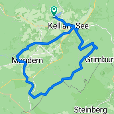
Oude spoorlijnroute Hermenskeil - Trier
A cycling route starting in Kell am See, Rhineland-Palatinate, Germany.
Overview
About this route
Old railway route Hermenskeil - Trier
- -:--
- Duration
- 45.6 km
- Distance
- 122 m
- Ascent
- 476 m
- Descent
- ---
- Avg. speed
- ---
- Max. altitude

Route quality
Waytypes & surfaces along the route
Waytypes
Path
31 km
(68 %)
Pedestrian area
3.2 km
(7 %)
Surfaces
Paved
37.8 km
(83 %)
Unpaved
0.5 km
(1 %)
Asphalt
29.2 km
(64 %)
Paved (undefined)
8.7 km
(19 %)
Continue with Bikemap
Use, edit, or download this cycling route
You would like to ride Oude spoorlijnroute Hermenskeil - Trier or customize it for your own trip? Here is what you can do with this Bikemap route:
Free features
- Save this route as favorite or in collections
- Copy & plan your own version of this route
- Sync your route with Garmin or Wahoo
Premium features
Free trial for 3 days, or one-time payment. More about Bikemap Premium.
- Navigate this route on iOS & Android
- Export a GPX / KML file of this route
- Create your custom printout (try it for free)
- Download this route for offline navigation
Discover more Premium features.
Get Bikemap PremiumFrom our community
Other popular routes starting in Kell am See
 Seeuferweg 2, Kell am See nach Metzelstraße 11, Trier
- Distance
- 24.9 km
- Ascent
- 483 m
- Descent
- 834 m
- Location
- Kell am See, Rhineland-Palatinate, Germany
 Seeuferweg nach Seeuferweg
- Distance
- 28.3 km
- Ascent
- 360 m
- Descent
- 365 m
- Location
- Kell am See, Rhineland-Palatinate, Germany
 oude spoorlijn
- Distance
- 36.5 km
- Ascent
- 170 m
- Descent
- 532 m
- Location
- Kell am See, Rhineland-Palatinate, Germany
 Oude spoorlijnroute Hermenskeil - Trier
- Distance
- 45.6 km
- Ascent
- 122 m
- Descent
- 476 m
- Location
- Kell am See, Rhineland-Palatinate, Germany
 kell am see
- Distance
- 9.8 km
- Ascent
- 168 m
- Descent
- 135 m
- Location
- Kell am See, Rhineland-Palatinate, Germany
 Tour 12c, Kell am See 5 Wie
- Distance
- 2 km
- Ascent
- 29 m
- Descent
- 26 m
- Location
- Kell am See, Rhineland-Palatinate, Germany
 Kell am See - Saarburg
- Distance
- 26.5 km
- Ascent
- 173 m
- Descent
- 491 m
- Location
- Kell am See, Rhineland-Palatinate, Germany
 Seeuferweg nach Seeuferweg
- Distance
- 28.3 km
- Ascent
- 360 m
- Descent
- 362 m
- Location
- Kell am See, Rhineland-Palatinate, Germany
Open it in the app