
027 - 2014
A cycling route starting in Höchst, Vorarlberg, Austria.
Overview
About this route
18 lipiec - 27 dzień wyprawy rowerowej Italia & Alpy 2014
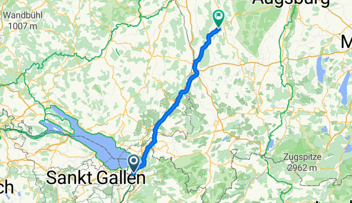
Lustenau - Krumbach /114 km- -:--
- Duration
- 114.1 km
- Distance
- 504 m
- Ascent
- 333 m
- Descent
- ---
- Avg. speed
- ---
- Max. altitude

Route quality
Waytypes & surfaces along the route
Waytypes
Road
12.6 km
(11 %)
Path
9.1 km
(8 %)
Surfaces
Paved
107.3 km
(94 %)
Asphalt
107.3 km
(94 %)
Undefined
6.8 km
(6 %)
Route highlights
Points of interest along the route

Point of interest after 114.1 km
18.07.2014 - Biwak na dziko przed Krumbach (Schwaben)
Continue with Bikemap
Use, edit, or download this cycling route
You would like to ride 027 - 2014 or customize it for your own trip? Here is what you can do with this Bikemap route:
Free features
- Save this route as favorite or in collections
- Copy & plan your own version of this route
- Split it into stages to create a multi-day tour
- Sync your route with Garmin or Wahoo
Premium features
Free trial for 3 days, or one-time payment. More about Bikemap Premium.
- Navigate this route on iOS & Android
- Export a GPX / KML file of this route
- Create your custom printout (try it for free)
- Download this route for offline navigation
Discover more Premium features.
Get Bikemap PremiumFrom our community
Other popular routes starting in Höchst
 ÄL?›? nach ÄL?›?
- Distance
- 15 km
- Ascent
- 6 m
- Descent
- 6 m
- Location
- Höchst, Vorarlberg, Austria
 Bodensee Radltag 2 - 26.6.22 Höchst nach Konstanz
- Distance
- 52.9 km
- Ascent
- 208 m
- Descent
- 202 m
- Location
- Höchst, Vorarlberg, Austria
 Höchst - Heldsberg - Sommerau - Augsti - Zelg - Plätzli - Lutzenberg - Rheineck - Höchst
- Distance
- 27 km
- Ascent
- 684 m
- Descent
- 687 m
- Location
- Höchst, Vorarlberg, Austria
 Walzenhausen - St. Anton
- Distance
- 37.3 km
- Ascent
- 919 m
- Descent
- 916 m
- Location
- Höchst, Vorarlberg, Austria
 BS3 - Zur Linde (Höchst) - Augustiner Tor Konstanz
- Distance
- 52.5 km
- Ascent
- 60 m
- Descent
- 61 m
- Location
- Höchst, Vorarlberg, Austria
 Höchst - Rheineck - Wienacht - Heiden - Trogen - Gäbris - St. Anton - Berneck - Höchst
- Distance
- 62.1 km
- Ascent
- 1,249 m
- Descent
- 1,249 m
- Location
- Höchst, Vorarlberg, Austria
 027 - 2014
- Distance
- 114.1 km
- Ascent
- 504 m
- Descent
- 333 m
- Location
- Höchst, Vorarlberg, Austria
 Schäflisberg - Heldsberg - Walzenhausen und retour
- Distance
- 13.8 km
- Ascent
- 455 m
- Descent
- 456 m
- Location
- Höchst, Vorarlberg, Austria
Open it in the app