

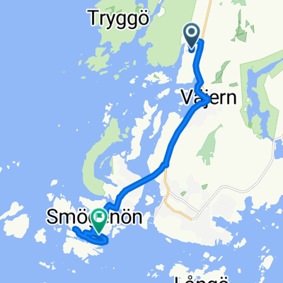
10. Etappe (Kungshamn - Lysekil) 48
A cycling route starting in Kungshamn, Västra Götaland County, Sweden.
Overview
About this route
<p>
10. stage (Kungshamn - Lysekil) 48</p>
Translated, show original (German)- -:--
- Duration
- 48 km
- Distance
- 326 m
- Ascent
- 312 m
- Descent
- ---
- Avg. speed
- ---
- Max. altitude
Route quality
Waytypes & surfaces along the route
Waytypes
Road
23.5 km
(49 %)
Path
1.4 km
(3 %)
Surfaces
Paved
45.1 km
(94 %)
Asphalt
37.9 km
(79 %)
Paved (undefined)
7.2 km
(15 %)
Undefined
2.9 km
(6 %)
Continue with Bikemap
Use, edit, or download this cycling route
You would like to ride 10. Etappe (Kungshamn - Lysekil) 48 or customize it for your own trip? Here is what you can do with this Bikemap route:
Free features
- Save this route as favorite or in collections
- Copy & plan your own version of this route
- Sync your route with Garmin or Wahoo
Premium features
Free trial for 3 days, or one-time payment. More about Bikemap Premium.
- Navigate this route on iOS & Android
- Export a GPX / KML file of this route
- Create your custom printout (try it for free)
- Download this route for offline navigation
Discover more Premium features.
Get Bikemap PremiumFrom our community
Other popular routes starting in Kungshamn
 Långevik naar Fiskhamnsgatan
- Distance
- 8.4 km
- Ascent
- 51 m
- Descent
- 98 m
- Location
- Kungshamn, Västra Götaland County, Sweden
 11. Etappe (Johannesviks Lysekil) 42
- Distance
- 42.7 km
- Ascent
- 231 m
- Descent
- 230 m
- Location
- Kungshamn, Västra Götaland County, Sweden
 10. Etappe (Kungshamn - Lysekil) 48
- Distance
- 48 km
- Ascent
- 326 m
- Descent
- 312 m
- Location
- Kungshamn, Västra Götaland County, Sweden
 Smögen
- Distance
- 66.1 km
- Ascent
- 324 m
- Descent
- 327 m
- Location
- Kungshamn, Västra Götaland County, Sweden
 58.371° N 11.296° W nach 58.371° N 11.296° W
- Distance
- 27 km
- Ascent
- 276 m
- Descent
- 291 m
- Location
- Kungshamn, Västra Götaland County, Sweden
Open it in the app