

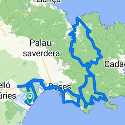
EmpuriaBrava -Punta Falconera
A cycling route starting in Empuriabrava, Catalonia, Spain.
Overview
About this route
Best to start before 8:00 AM Then there are few cars in the mountains + Riding is done in the mountain shade
- -:--
- Duration
- 31 km
- Distance
- 460 m
- Ascent
- 456 m
- Descent
- ---
- Avg. speed
- 176 m
- Max. altitude
Route quality
Waytypes & surfaces along the route
Waytypes
Quiet road
17.7 km
(57 %)
Road
5.6 km
(18 %)
Surfaces
Paved
15.8 km
(51 %)
Unpaved
1.6 km
(5 %)
Asphalt
15.2 km
(49 %)
Ground
1.6 km
(5 %)
Continue with Bikemap
Use, edit, or download this cycling route
You would like to ride EmpuriaBrava -Punta Falconera or customize it for your own trip? Here is what you can do with this Bikemap route:
Free features
- Save this route as favorite or in collections
- Copy & plan your own version of this route
- Sync your route with Garmin or Wahoo
Premium features
Free trial for 3 days, or one-time payment. More about Bikemap Premium.
- Navigate this route on iOS & Android
- Export a GPX / KML file of this route
- Create your custom printout (try it for free)
- Download this route for offline navigation
Discover more Premium features.
Get Bikemap PremiumFrom our community
Other popular routes starting in Empuriabrava
 MTB-Tour Cala Montjoi-Cadaques-Puig Alt
- Distance
- 70.5 km
- Ascent
- 837 m
- Descent
- 837 m
- Location
- Empuriabrava, Catalonia, Spain
 EmpuriaBrava -Punta Falconera
- Distance
- 31 km
- Ascent
- 460 m
- Descent
- 456 m
- Location
- Empuriabrava, Catalonia, Spain
 Ruta dels Aiguamolls cde l'Empordà (llarga)
- Distance
- 37.4 km
- Ascent
- 43 m
- Descent
- 41 m
- Location
- Empuriabrava, Catalonia, Spain
 Salins 2 Linia, 15, Castelló d'Empúries to Salins 2 Linia, 16, Castelló d'Empúries
- Distance
- 30.1 km
- Ascent
- 13 m
- Descent
- 13 m
- Location
- Empuriabrava, Catalonia, Spain
 Apuriabrava - offroad Runde
- Distance
- 38.2 km
- Ascent
- 71 m
- Descent
- 71 m
- Location
- Empuriabrava, Catalonia, Spain
 Empuriabrava-Porte de Selva-Empuriabrava
- Distance
- 78.6 km
- Ascent
- 1,021 m
- Descent
- 1,032 m
- Location
- Empuriabrava, Catalonia, Spain
 Empuriabrava- Castello Empuria und retour 05.11.16, 13:30
- Distance
- 14.7 km
- Ascent
- 23 m
- Descent
- 21 m
- Location
- Empuriabrava, Catalonia, Spain
 Parc Natural Cap Creus
- Distance
- 69.2 km
- Ascent
- 1,533 m
- Descent
- 1,450 m
- Location
- Empuriabrava, Catalonia, Spain
Open it in the app