

Abendrunde um den Tüllinger Berg
A cycling route starting in Steinen, Baden-Wurttemberg, Germany.
Overview
About this route
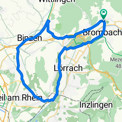
From Hauingen via Röttelnweiler and the Lucke into the Markgräfler Land to Rümmingen, Binzen, Haltingen, and Weil, and back through Switzerland to Lörrach. Actually quite flat, only through the Lucke you have to do a small climb. You stay at the foot of the Tüllingers and circle around it.
- -:--
- Duration
- 22.1 km
- Distance
- 157 m
- Ascent
- 161 m
- Descent
- ---
- Avg. speed
- 364 m
- Max. altitude
Route quality
Waytypes & surfaces along the route
Waytypes
Road
4.6 km
(21 %)
Access road
3.5 km
(16 %)
Surfaces
Paved
13.5 km
(61 %)
Unpaved
0.9 km
(4 %)
Asphalt
13 km
(59 %)
Paved (undefined)
0.4 km
(2 %)
Continue with Bikemap
Use, edit, or download this cycling route
You would like to ride Abendrunde um den Tüllinger Berg or customize it for your own trip? Here is what you can do with this Bikemap route:
Free features
- Save this route as favorite or in collections
- Copy & plan your own version of this route
- Sync your route with Garmin or Wahoo
Premium features
Free trial for 3 days, or one-time payment. More about Bikemap Premium.
- Navigate this route on iOS & Android
- Export a GPX / KML file of this route
- Create your custom printout (try it for free)
- Download this route for offline navigation
Discover more Premium features.
Get Bikemap PremiumFrom our community
Other popular routes starting in Steinen
 Abendrunde um den Tüllinger Berg
- Distance
- 22.1 km
- Ascent
- 157 m
- Descent
- 161 m
- Location
- Steinen, Baden-Wurttemberg, Germany
 Thomas tour
- Distance
- 45.2 km
- Ascent
- 752 m
- Descent
- 752 m
- Location
- Steinen, Baden-Wurttemberg, Germany
 SBF MTB 20190425
- Distance
- 27 km
- Ascent
- 430 m
- Descent
- 427 m
- Location
- Steinen, Baden-Wurttemberg, Germany
 RR-Stei-Schl-Muelle-Feldb-Ka-Stei
- Distance
- 69.4 km
- Ascent
- 715 m
- Descent
- 715 m
- Location
- Steinen, Baden-Wurttemberg, Germany
 MTB: Chrishona-Runde
- Distance
- 19.7 km
- Ascent
- 469 m
- Descent
- 469 m
- Location
- Steinen, Baden-Wurttemberg, Germany
 Steinen-Schluchsee-Albtal
- Distance
- 144.7 km
- Ascent
- 0 m
- Descent
- 0 m
- Location
- Steinen, Baden-Wurttemberg, Germany
 Steinen-Brombach-Rührberg-Herten-Degerfelden-Eichberg-Hüsingen-Steinen
- Distance
- 37.2 km
- Ascent
- 624 m
- Descent
- 625 m
- Location
- Steinen, Baden-Wurttemberg, Germany
 Wiesental-Hotzenwald-Tour
- Distance
- 106.3 km
- Ascent
- 0 m
- Descent
- 0 m
- Location
- Steinen, Baden-Wurttemberg, Germany
Open it in the app