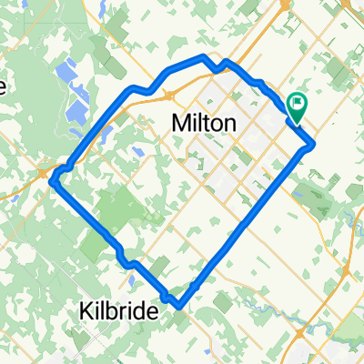
Hornby 80K
A cycling route starting in Milton, Ontario, Canada.
Overview
About this route
great parking at Hornby park
6th Line has construction in 2009
- -:--
- Duration
- 75.4 km
- Distance
- 330 m
- Ascent
- 240 m
- Descent
- ---
- Avg. speed
- 342 m
- Max. altitude
Route quality
Waytypes & surfaces along the route
Waytypes
Road
42.2 km
(56 %)
Quiet road
9 km
(12 %)
Surfaces
Paved
58.8 km
(78 %)
Unpaved
1.5 km
(2 %)
Asphalt
58.8 km
(78 %)
Unpaved (undefined)
1.5 km
(2 %)
Undefined
15.1 km
(20 %)
Continue with Bikemap
Use, edit, or download this cycling route
You would like to ride Hornby 80K or customize it for your own trip? Here is what you can do with this Bikemap route:
Free features
- Save this route as favorite or in collections
- Copy & plan your own version of this route
- Sync your route with Garmin or Wahoo
Premium features
Free trial for 3 days, or one-time payment. More about Bikemap Premium.
- Navigate this route on iOS & Android
- Export a GPX / KML file of this route
- Create your custom printout (try it for free)
- Download this route for offline navigation
Discover more Premium features.
Get Bikemap PremiumFrom our community
Other popular routes starting in Milton
- HILTON FALLS
- Distance
- 9.4 km
- Ascent
- 48 m
- Descent
- 32 m
- Location
- Milton, Ontario, Canada
- Hornby 80K
- Distance
- 75.4 km
- Ascent
- 330 m
- Descent
- 240 m
- Location
- Milton, Ontario, Canada
- Cusick Circle 429, Milton to Cusick Circle 420, Milton
- Distance
- 20 km
- Ascent
- 193 m
- Descent
- 195 m
- Location
- Milton, Ontario, Canada
- May242025-TourDeIsmaili
- Distance
- 54.8 km
- Ascent
- 304 m
- Descent
- 307 m
- Location
- Milton, Ontario, Canada
- 26K Start Season - Not much Hill
- Distance
- 27.6 km
- Ascent
- 86 m
- Descent
- 87 m
- Location
- Milton, Ontario, Canada
- Practice Route 03 - 38km
- Distance
- 38 km
- Ascent
- 112 m
- Descent
- 115 m
- Location
- Milton, Ontario, Canada
- Waterdown and back
- Distance
- 72.6 km
- Ascent
- 257 m
- Descent
- 257 m
- Location
- Milton, Ontario, Canada
- 100K - June 27
- Distance
- 99.6 km
- Ascent
- 336 m
- Descent
- 337 m
- Location
- Milton, Ontario, Canada
Open it in the app