
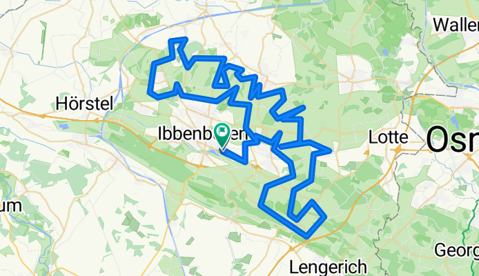
TECKELENBURG RONDE
A cycling route starting in Ibbenbueren, North Rhine-Westphalia, Germany.
Overview
About this route
TEASI track (cloned from route 2750125)
- -:--
- Duration
- 101.2 km
- Distance
- 868 m
- Ascent
- 867 m
- Descent
- ---
- Avg. speed
- ---
- Max. altitude
Route quality
Waytypes & surfaces along the route
Waytypes
Quiet road
67.8 km
(67 %)
Road
11.1 km
(11 %)
Surfaces
Paved
61.7 km
(61 %)
Unpaved
1 km
(1 %)
Asphalt
61.7 km
(61 %)
Ground
1 km
(1 %)
Undefined
38.5 km
(38 %)
Continue with Bikemap
Use, edit, or download this cycling route
You would like to ride TECKELENBURG RONDE or customize it for your own trip? Here is what you can do with this Bikemap route:
Free features
- Save this route as favorite or in collections
- Copy & plan your own version of this route
- Split it into stages to create a multi-day tour
- Sync your route with Garmin or Wahoo
Premium features
Free trial for 3 days, or one-time payment. More about Bikemap Premium.
- Navigate this route on iOS & Android
- Export a GPX / KML file of this route
- Create your custom printout (try it for free)
- Download this route for offline navigation
Discover more Premium features.
Get Bikemap PremiumFrom our community
Other popular routes starting in Ibbenbueren
 Teutorundfahrt
- Distance
- 36.5 km
- Ascent
- 135 m
- Descent
- 138 m
- Location
- Ibbenbueren, North Rhine-Westphalia, Germany
 Teutoburgerwaldtocht 85km
- Distance
- 86.5 km
- Ascent
- 960 m
- Descent
- 922 m
- Location
- Ibbenbueren, North Rhine-Westphalia, Germany
 Tour nördl. Ibbenbüren
- Distance
- 50.5 km
- Ascent
- 156 m
- Descent
- 169 m
- Location
- Ibbenbueren, North Rhine-Westphalia, Germany
 Dickenberg-Bramsche-Dickenberg
- Distance
- 66.7 km
- Ascent
- 163 m
- Descent
- 163 m
- Location
- Ibbenbueren, North Rhine-Westphalia, Germany
 Ausfahrt Marathon Ibbenbüren 25.07.2009
- Distance
- 56 km
- Ascent
- 302 m
- Descent
- 302 m
- Location
- Ibbenbueren, North Rhine-Westphalia, Germany
 Teutoburgerwaldtocht
- Distance
- 86.7 km
- Ascent
- 1,002 m
- Descent
- 941 m
- Location
- Ibbenbueren, North Rhine-Westphalia, Germany
 Ibbenbüren - Wersen
- Distance
- 39.8 km
- Ascent
- 210 m
- Descent
- 210 m
- Location
- Ibbenbueren, North Rhine-Westphalia, Germany
 TECKELENBURG RONDE
- Distance
- 101.2 km
- Ascent
- 868 m
- Descent
- 867 m
- Location
- Ibbenbueren, North Rhine-Westphalia, Germany
Open it in the app