
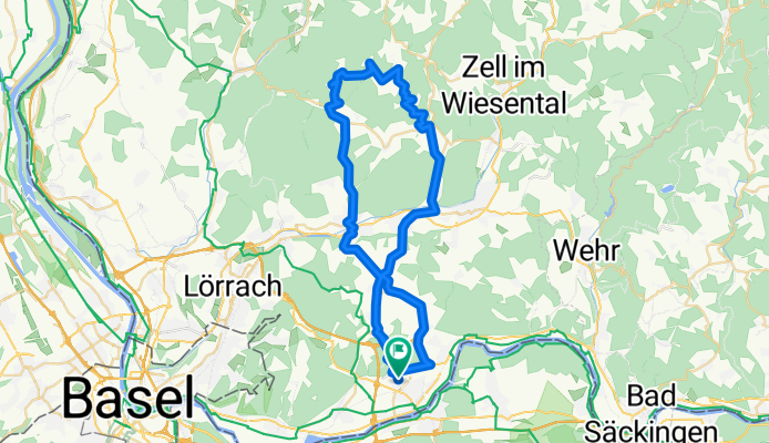
Nollingen - Eichholz Endenburg Nollingen
A cycling route starting in Rheinfelden, Baden-Wurttemberg, Germany.
Overview
About this route
None (cloned from route 1236204)
- -:--
- Duration
- 52.4 km
- Distance
- 705 m
- Ascent
- 704 m
- Descent
- ---
- Avg. speed
- ---
- Max. altitude
Route quality
Waytypes & surfaces along the route
Waytypes
Quiet road
16.8 km
(32 %)
Road
13.6 km
(26 %)
Surfaces
Paved
41.4 km
(79 %)
Unpaved
0.5 km
(1 %)
Asphalt
41.4 km
(79 %)
Gravel
0.5 km
(1 %)
Undefined
10.5 km
(20 %)
Continue with Bikemap
Use, edit, or download this cycling route
You would like to ride Nollingen - Eichholz Endenburg Nollingen or customize it for your own trip? Here is what you can do with this Bikemap route:
Free features
- Save this route as favorite or in collections
- Copy & plan your own version of this route
- Sync your route with Garmin or Wahoo
Premium features
Free trial for 3 days, or one-time payment. More about Bikemap Premium.
- Navigate this route on iOS & Android
- Export a GPX / KML file of this route
- Create your custom printout (try it for free)
- Download this route for offline navigation
Discover more Premium features.
Get Bikemap PremiumFrom our community
Other popular routes starting in Rheinfelden
 1a2
1a2- Distance
- 36.4 km
- Ascent
- 267 m
- Descent
- 266 m
- Location
- Rheinfelden, Baden-Wurttemberg, Germany
 Rheinfelden - Ottmarsheim
- Distance
- 62.8 km
- Ascent
- 166 m
- Descent
- 278 m
- Location
- Rheinfelden, Baden-Wurttemberg, Germany
 Triathlon Rheinfelden.gpx
- Distance
- 43.9 km
- Ascent
- 493 m
- Descent
- 493 m
- Location
- Rheinfelden, Baden-Wurttemberg, Germany
 1234
1234- Distance
- 40.9 km
- Ascent
- 147 m
- Descent
- 158 m
- Location
- Rheinfelden, Baden-Wurttemberg, Germany
 Rheinfelden - Algolsheim
- Distance
- 76.2 km
- Ascent
- 54 m
- Descent
- 148 m
- Location
- Rheinfelden, Baden-Wurttemberg, Germany
 Nollingen - Eichholz Endenburg Nollingen
- Distance
- 52.4 km
- Ascent
- 705 m
- Descent
- 704 m
- Location
- Rheinfelden, Baden-Wurttemberg, Germany
 St. Chrischona - Adelhausen
- Distance
- 34.4 km
- Ascent
- 470 m
- Descent
- 468 m
- Location
- Rheinfelden, Baden-Wurttemberg, Germany
 Tour de Dinkelberg
- Distance
- 36.2 km
- Ascent
- 443 m
- Descent
- 443 m
- Location
- Rheinfelden, Baden-Wurttemberg, Germany
Open it in the app