

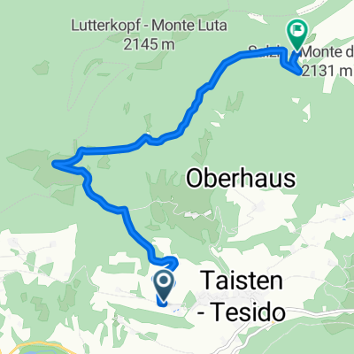
Dolomiti: Monguelfo-St.Vigil-Monguelfo
A cycling route starting in Welsberg-Taisten, Trentino-Alto Adige, Italy.
Overview
About this route
Beautiful MTB route through Fanes-Sennes-Braies Park
- -:--
- Duration
- 88.2 km
- Distance
- 2,317 m
- Ascent
- 2,295 m
- Descent
- ---
- Avg. speed
- ---
- Max. altitude

Continue with Bikemap
Use, edit, or download this cycling route
You would like to ride Dolomiti: Monguelfo-St.Vigil-Monguelfo or customize it for your own trip? Here is what you can do with this Bikemap route:
Free features
- Save this route as favorite or in collections
- Copy & plan your own version of this route
- Split it into stages to create a multi-day tour
- Sync your route with Garmin or Wahoo
Premium features
Free trial for 3 days, or one-time payment. More about Bikemap Premium.
- Navigate this route on iOS & Android
- Export a GPX / KML file of this route
- Create your custom printout (try it for free)
- Download this route for offline navigation
Discover more Premium features.
Get Bikemap PremiumFrom our community
Other popular routes starting in Welsberg-Taisten
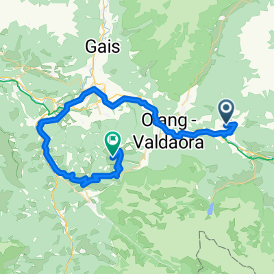
 Welsberg - Taisten - Olang - Saller - Welsberg
- Distance
- 24.2 km
- Ascent
- 1,248 m
- Descent
- 1,148 m
- Location
- Welsberg-Taisten, Trentino-Alto Adige, Italy
 Taisten - Taistner Vorderalm
- Distance
- 7.8 km
- Ascent
- 742 m
- Descent
- 53 m
- Location
- Welsberg-Taisten, Trentino-Alto Adige, Italy
 Welsberg - Kronplatz
- Distance
- 49.1 km
- Ascent
- 2,162 m
- Descent
- 1,200 m
- Location
- Welsberg-Taisten, Trentino-Alto Adige, Italy
 Drei Zinnen und nach Süden
- Distance
- 71.8 km
- Ascent
- 660 m
- Descent
- 1,025 m
- Location
- Welsberg-Taisten, Trentino-Alto Adige, Italy
 Dolomiti: Monguelfo-St.Vigil-Monguelfo
- Distance
- 88.2 km
- Ascent
- 2,317 m
- Descent
- 2,295 m
- Location
- Welsberg-Taisten, Trentino-Alto Adige, Italy
 Taisten - Plätzwiese - Taisten
- Distance
- 59.2 km
- Ascent
- 1,288 m
- Descent
- 1,285 m
- Location
- Welsberg-Taisten, Trentino-Alto Adige, Italy
 Taisten - Antholzer See
- Distance
- 26.6 km
- Ascent
- 868 m
- Descent
- 516 m
- Location
- Welsberg-Taisten, Trentino-Alto Adige, Italy
 My Tesido Gravel Tour
- Distance
- 116 km
- Ascent
- 2,842 m
- Descent
- 2,840 m
- Location
- Welsberg-Taisten, Trentino-Alto Adige, Italy
Open it in the app