
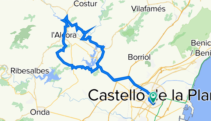
14-8-13-Cs-Gaeta-Pantano-LagoVerde-Alcora-ElCastell-LaFoya-Moro-Cs
A cycling route starting in Castellon, Valencia, Spain.
Overview
About this route
- -:--
- Duration
- 61 km
- Distance
- 522 m
- Ascent
- 521 m
- Descent
- ---
- Avg. speed
- ---
- Max. altitude

Continue with Bikemap
Use, edit, or download this cycling route
You would like to ride 14-8-13-Cs-Gaeta-Pantano-LagoVerde-Alcora-ElCastell-LaFoya-Moro-Cs or customize it for your own trip? Here is what you can do with this Bikemap route:
Free features
- Save this route as favorite or in collections
- Copy & plan your own version of this route
- Sync your route with Garmin or Wahoo
Premium features
Free trial for 3 days, or one-time payment. More about Bikemap Premium.
- Navigate this route on iOS & Android
- Export a GPX / KML file of this route
- Create your custom printout (try it for free)
- Download this route for offline navigation
Discover more Premium features.
Get Bikemap PremiumFrom our community
Other popular routes starting in Castellon
 Castellon - Amposta
- Distance
- 132 km
- Ascent
- 797 m
- Descent
- 814 m
- Location
- Castellon, Valencia, Spain
 Desierto
- Distance
- 37.5 km
- Ascent
- 441 m
- Descent
- 442 m
- Location
- Castellon, Valencia, Spain
 Nº 1 SANT ROC DE CANET - LLEDO.
- Distance
- 7.8 km
- Ascent
- 9 m
- Descent
- 17 m
- Location
- Castellon, Valencia, Spain
 Nº 3 SENILLAR - MOLI LA FONT.
- Distance
- 12.8 km
- Ascent
- 13 m
- Descent
- 20 m
- Location
- Castellon, Valencia, Spain
 Castelló - Serra d'Orpesa - Castelló
- Distance
- 52.3 km
- Ascent
- 486 m
- Descent
- 486 m
- Location
- Castellon, Valencia, Spain
 Relaxed route in Borriana
- Distance
- 21 km
- Ascent
- 75 m
- Descent
- 64 m
- Location
- Castellon, Valencia, Spain
 14-8-13-Cs-Gaeta-Pantano-LagoVerde-Alcora-ElCastell-LaFoya-Moro-Cs
- Distance
- 61 km
- Ascent
- 522 m
- Descent
- 521 m
- Location
- Castellon, Valencia, Spain
 Nº 8 FONT DE LA SALUD – MAGDALENA.
- Distance
- 25.3 km
- Ascent
- 340 m
- Descent
- 340 m
- Location
- Castellon, Valencia, Spain
Open it in the app