

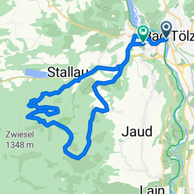
Große Tölzer Kirchsee-Tour
A cycling route starting in Bad Tölz, Bavaria, Germany.
Overview
About this route
<span>Mosers „Große“ Tölzer Kirchsee-Runde aus seinem Bike-Guide 7, Tour 17. Tour nachgefahren und mit GPS aufgezeichnet. </span>
<span>Landschaftlich reizvolle Fahrt durch die „Attenloher Filzen“ südlich von Bad Tölz. Wochentags eine schöne einsame Runde, am Wochenende jedoch muss, analog zur „Kleinen Kirchsee-Runde“, <span> </span>rund um den Kirchsee mit erhöhtem „Verkehrsaufkommen“ (Wanderer, Biker, Badegäste) gerechnet werden. Eine Einkehr im „Gasthof Kloster Reutberg“ ist bei dieser Runde fast ein Muss!!! </span> <span>Beschreibung nach Moser: Schöne Fahrt von Bad Tölz über das landschaftlich reizvoll gelegene Dörfchen Gaißach und durch das einsame Gaißachtälchen. Herrliche Bademöglichkeiten am Kirchsee, der mit seiner idyllischen Lage und den Bergen im Hintergrund herausragt. Ein Abstecher zum einsameren Südufer des Sees lohnt sich! </span> <span>Bewertung nach Moser: Etwas längere der beiden Kirchsee-Touren, die wegen einiger Auffahrten nur ein wenig Kondition erfordert. Sonst keine Schwierigkeiten. </span> <span>Bike-Spaß: 2 Sterne (von 6); Landschaft: 3 (6); Kondition: 2 (6), Technik: 1 (6) </span> <span>Ergänzung: Lt. GPS-Gerät = 418 Höhenmeter </span>- -:--
- Duration
- 36.1 km
- Distance
- 270 m
- Ascent
- 270 m
- Descent
- ---
- Avg. speed
- ---
- Max. altitude

Route quality
Waytypes & surfaces along the route
Waytypes
Track
23.5 km
(65 %)
Quiet road
8.7 km
(24 %)
Surfaces
Paved
12.6 km
(35 %)
Unpaved
21.3 km
(59 %)
Gravel
10.5 km
(29 %)
Asphalt
10.1 km
(28 %)
Continue with Bikemap
Use, edit, or download this cycling route
You would like to ride Große Tölzer Kirchsee-Tour or customize it for your own trip? Here is what you can do with this Bikemap route:
Free features
- Save this route as favorite or in collections
- Copy & plan your own version of this route
- Sync your route with Garmin or Wahoo
Premium features
Free trial for 3 days, or one-time payment. More about Bikemap Premium.
- Navigate this route on iOS & Android
- Export a GPX / KML file of this route
- Create your custom printout (try it for free)
- Download this route for offline navigation
Discover more Premium features.
Get Bikemap PremiumFrom our community
Other popular routes starting in Bad Tölz
 Kleine Tölzer Kirchsee-Runde
- Distance
- 23.1 km
- Ascent
- 137 m
- Descent
- 137 m
- Location
- Bad Tölz, Bavaria, Germany
 Runde um Brauneck/Benediktenwand
- Distance
- 75.4 km
- Ascent
- 1,416 m
- Descent
- 1,416 m
- Location
- Bad Tölz, Bavaria, Germany
 Bad Tölz - München
- Distance
- 60.9 km
- Ascent
- 440 m
- Descent
- 574 m
- Location
- Bad Tölz, Bavaria, Germany
 München - Walchensee - München
- Distance
- 101.2 km
- Ascent
- 1,142 m
- Descent
- 1,081 m
- Location
- Bad Tölz, Bavaria, Germany
 Bad Tölz - Walchensee - Lenggries
- Distance
- 72.3 km
- Ascent
- 611 m
- Descent
- 611 m
- Location
- Bad Tölz, Bavaria, Germany
 Tölzer Isartal-Rundfahrt
- Distance
- 38.9 km
- Ascent
- 242 m
- Descent
- 242 m
- Location
- Bad Tölz, Bavaria, Germany
 Blomberg
- Distance
- 18.2 km
- Ascent
- 626 m
- Descent
- 614 m
- Location
- Bad Tölz, Bavaria, Germany
 Eichmühlstraße, Bad Tölz nach Lengries über Felder, Wiesen und Bauernhöfe zurück
- Distance
- 38.4 km
- Ascent
- 690 m
- Descent
- 696 m
- Location
- Bad Tölz, Bavaria, Germany
Open it in the app