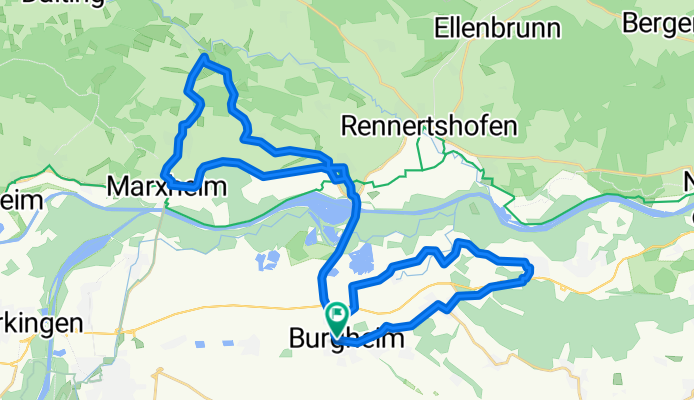
Über dem Donautal
A cycling route starting in Burgheim, Bavaria, Germany.
Overview
About this route
Strecke führt die Donautalstrasse hoch über die Donau, am höchsten Punkt hat man einen schönen Blick über das Donautal, im Osten nach Neuburg, im Süden in das Donaumoos und in Richtung Westen nach Rain am Lech
- -:--
- Duration
- 42.2 km
- Distance
- 255 m
- Ascent
- 246 m
- Descent
- ---
- Avg. speed
- 519 m
- Avg. speed
Route quality
Waytypes & surfaces along the route
Waytypes
Road
16.2 km
(38 %)
Quiet road
12.6 km
(30 %)
Surfaces
Paved
35 km
(83 %)
Unpaved
0.1 km
(<1 %)
Asphalt
34.6 km
(82 %)
Paved (undefined)
0.4 km
(<1 %)
Continue with Bikemap
Use, edit, or download this cycling route
You would like to ride Über dem Donautal or customize it for your own trip? Here is what you can do with this Bikemap route:
Free features
- Save this route as favorite or in collections
- Copy & plan your own version of this route
- Sync your route with Garmin or Wahoo
Premium features
Free trial for 3 days, or one-time payment. More about Bikemap Premium.
- Navigate this route on iOS & Android
- Export a GPX / KML file of this route
- Create your custom printout (try it for free)
- Download this route for offline navigation
Discover more Premium features.
Get Bikemap PremiumFrom our community
Other popular routes starting in Burgheim
- Über dem Donautal
- Distance
- 42.2 km
- Ascent
- 255 m
- Descent
- 246 m
- Location
- Burgheim, Bavaria, Germany
- Feierabendrunde CLONED FROM ROUTE 145781
- Distance
- 23.5 km
- Ascent
- 183 m
- Descent
- 183 m
- Location
- Burgheim, Bavaria, Germany
- Drei-Landkreis-Runde
- Distance
- 62.6 km
- Ascent
- 694 m
- Descent
- 697 m
- Location
- Burgheim, Bavaria, Germany
- trainingsrunde
- Distance
- 81.3 km
- Ascent
- 715 m
- Descent
- 712 m
- Location
- Burgheim, Bavaria, Germany
- Vatertag Tour
- Distance
- 44.2 km
- Ascent
- 244 m
- Descent
- 244 m
- Location
- Burgheim, Bavaria, Germany
- Burgheim - Spindeltal
- Distance
- 42.3 km
- Ascent
- 390 m
- Descent
- 392 m
- Location
- Burgheim, Bavaria, Germany
- Bahnhofstraße 38B, Burgheim nach Rathausplatz, Ingolstadt
- Distance
- 44.6 km
- Ascent
- 389 m
- Descent
- 401 m
- Location
- Burgheim, Bavaria, Germany
- Rechts und links vom Lech - Variante Kraftwerk
- Distance
- 53.9 km
- Ascent
- 88 m
- Descent
- 89 m
- Location
- Burgheim, Bavaria, Germany
Open it in the app