

Münchner Perlacher Forst-Trails (Variante B)
A cycling route starting in Unterhaching, Bavaria, Germany.
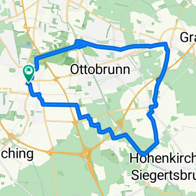
Overview
About this route
Mosers 'Perlacher Forst-Trail-Tour according to his bike guide 7, tour variant 6b. The overgrowth required slight changes in the route, but this should not affect the fun of riding it (ridden and recorded with GPS on 16.05.14).
Rating according to Moser: Wooded route predominantly running on the hidden, idyllic little bike paths and trails through the Perlacher Forst.
Difficulty level: Apart from some sections that are slightly bumpy, the majority of paths and trails are passable without any special difficulties.
Bike fun: 3 stars (out of 6); Condition: 1 star (6); Riding technique: 2 stars (6)
Translated, show original (German)- -:--
- Duration
- 11.7 km
- Distance
- 12 m
- Ascent
- 12 m
- Descent
- ---
- Avg. speed
- ---
- Max. altitude

Route quality
Waytypes & surfaces along the route
Waytypes
Path
9.1 km
(78 %)
Track
2.1 km
(18 %)
Surfaces
Paved
0.9 km
(8 %)
Unpaved
10.5 km
(90 %)
Ground
6.3 km
(54 %)
Gravel
2.2 km
(19 %)
Continue with Bikemap
Use, edit, or download this cycling route
You would like to ride Münchner Perlacher Forst-Trails (Variante B) or customize it for your own trip? Here is what you can do with this Bikemap route:
Free features
- Save this route as favorite or in collections
- Copy & plan your own version of this route
- Sync your route with Garmin or Wahoo
Premium features
Free trial for 3 days, or one-time payment. More about Bikemap Premium.
- Navigate this route on iOS & Android
- Export a GPX / KML file of this route
- Create your custom printout (try it for free)
- Download this route for offline navigation
Discover more Premium features.
Get Bikemap PremiumFrom our community
Other popular routes starting in Unterhaching
 200km + Klettertour
- Distance
- 203.6 km
- Ascent
- 1,284 m
- Descent
- 1,235 m
- Location
- Unterhaching, Bavaria, Germany
 Perlacher Forst - Ascholding
- Distance
- 67.7 km
- Ascent
- 485 m
- Descent
- 463 m
- Location
- Unterhaching, Bavaria, Germany
 Perlacher Forst nach Bad Tölz
- Distance
- 87 km
- Ascent
- 416 m
- Descent
- 414 m
- Location
- Unterhaching, Bavaria, Germany
 Wendelstein Runde
- Distance
- 176.6 km
- Ascent
- 1,432 m
- Descent
- 1,377 m
- Location
- Unterhaching, Bavaria, Germany
 Feierabendrunde: Ludwigshöhe
- Distance
- 36.6 km
- Ascent
- 188 m
- Descent
- 200 m
- Location
- Unterhaching, Bavaria, Germany
 Münchner Feierabendrunde
- Distance
- 42 km
- Ascent
- 311 m
- Descent
- 311 m
- Location
- Unterhaching, Bavaria, Germany
 Münchner Forste-Gleißental-Trailtour
- Distance
- 35.5 km
- Ascent
- 87 m
- Descent
- 88 m
- Location
- Unterhaching, Bavaria, Germany
 rundtour Putzbrunn
- Distance
- 25.3 km
- Ascent
- 33 m
- Descent
- 31 m
- Location
- Unterhaching, Bavaria, Germany
Open it in the app