Selkirk to ullapool
- 850.2 km
- 7,197 m
- 7,361 m
- Selkirk, Scotland, United Kingdom
A cycling route starting in Selkirk, Scotland, United Kingdom.
Overview
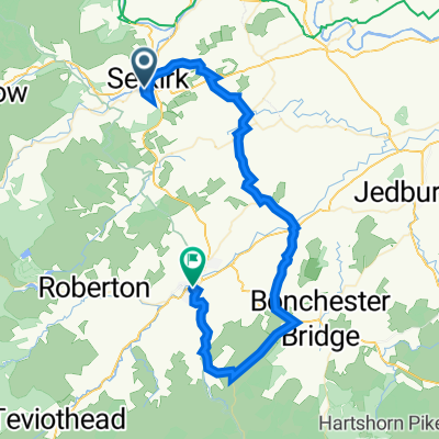
From Selkirk town centre, go west down hill( A707) and cross bridge. After 200 m take left onto road signposted Philiphaugh. After 300 m this joins the A708 to St Mary's Loch, a country road with grass verge. After 400 m arrive at memorial stone to the Battle of Philiphaug h and take track beside road to cafe at Beechwood. Then, once again move on to road for 2 km to entrance of Bowhill estate. Cross river, Yarrow, and turn right onto Cross Borders Drove Road through Bowhill estate for 3 km, arriving back on A708 in Broadmeadows. Continue along road for 600 m, past telephone box, to turning North signposted Minch Moor. Follow road uphill until forestry track which leads to right. Take the wooden steps up onto trail and proceed over open moorland until it joins the Southern Upland Way.Continue West along Southern Upland Way past Minch Moor (567 m ) and then down into Traquair village. Continue North along B 709, across the bridge into Innerleithen (Shops, pubs, b&bs etc). You may want to stay here and leave the next 10 kms to Peebles for another day.
For Peebles, take the cycle track (called the Tweed Valley Railway Path and signposted to Cardrona, Glentress, Peebles) , along the north bank of the Tweed about 4 km, crossing a modern bridge and continuing through a golf course to arrive at the centre of Cardrona (Cardrona village store). Continue along rail path over another bridge onto the south side of the Tweed and past the MacDonald Cardrona Hotel. After 4 km the path goes underneath the main road (A72) , and up onto the other side for 1 km where it joins a T-junction. Turn left and proceed 200 m onto the main road. Turn right and continue along pavement and then turn left through gate onto tarmac track leading towards river. Continue past the leisure centre and another kilometre will take you into the centre of Peebles (shops, bars, B&Bs, etc )
This is the 7th section of the great pilgrim trail, St Wilfrid’s Way, from Hexham to Edinburgh and then on to St Andrews (website:http://www.thewayofstandrews.com/)
Photographs and comments needed through CONTACT ME on the website , The Way of St Andrews. http://www.thewayofstandrews.com
created this 11 years ago
Route highlights
Cross river into Bowhill Estate (cafe etc) and continue along Cross Borders Drove Road.
Wooden steps onto trail
Joins Southern Upland Way going east-west
Continue with Bikemap
You would like to ride St Wilfrid's Way -Selkirk to Peebles or customize it for your own trip? Here is what you can do with this Bikemap route:
Free trial for 3 days, or one-time payment. More about Bikemap Premium.
Discover more Premium features.
Get Bikemap PremiumFrom our community
Open it in the app