

Stage 7 Tour du Nord 2014 Hammer - Årup 199km
A cycling route starting in Tørring, Central Jutland, Denmark.
Overview
About this route
Stage 7 Tour du Nord 2014 Hammer - Årup 199km
- -:--
- Duration
- 199.3 km
- Distance
- 376 m
- Ascent
- 459 m
- Descent
- ---
- Avg. speed
- ---
- Avg. speed
Route quality
Waytypes & surfaces along the route
Waytypes
Cycleway
61.4 km
(31 %)
Busy road
51.9 km
(26 %)
Surfaces
Paved
166.2 km
(83 %)
Unpaved
24.8 km
(12 %)
Asphalt
160.6 km
(81 %)
Sand
20.1 km
(10 %)
Route highlights
Points of interest along the route
Point of interest after 13.4 km
Breakfast Spot
Point of interest after 141.9 km
Chill & Dinner Spot
Continue with Bikemap
Use, edit, or download this cycling route
You would like to ride Stage 7 Tour du Nord 2014 Hammer - Årup 199km or customize it for your own trip? Here is what you can do with this Bikemap route:
Free features
- Save this route as favorite or in collections
- Copy & plan your own version of this route
- Split it into stages to create a multi-day tour
- Sync your route with Garmin or Wahoo
Premium features
Free trial for 3 days, or one-time payment. More about Bikemap Premium.
- Navigate this route on iOS & Android
- Export a GPX / KML file of this route
- Create your custom printout (try it for free)
- Download this route for offline navigation
Discover more Premium features.
Get Bikemap PremiumFrom our community
Other popular routes starting in Tørring
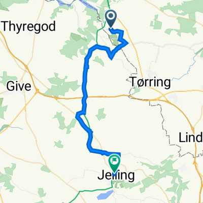 Koutrupvej 11, Tørring to Gorms Torv 7, Jelling
- Distance
- 28.2 km
- Ascent
- 175 m
- Descent
- 161 m
- Location
- Tørring, Central Jutland, Denmark
 Stage 7 Tour du Nord 2014 Hammer - Årup 199km
- Distance
- 199.3 km
- Ascent
- 376 m
- Descent
- 459 m
- Location
- Tørring, Central Jutland, Denmark
 PG Walk
- Distance
- 5.6 km
- Ascent
- 75 m
- Descent
- 77 m
- Location
- Tørring, Central Jutland, Denmark
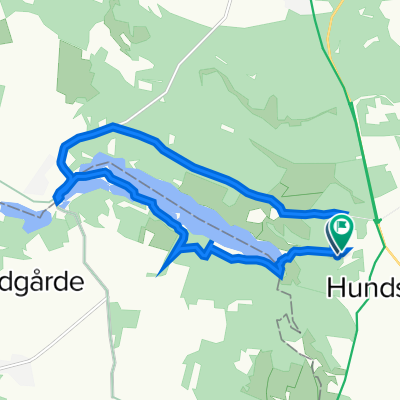
 Koutrup Sø til Bindeballe
- Distance
- 35.4 km
- Ascent
- 109 m
- Descent
- 163 m
- Location
- Tørring, Central Jutland, Denmark
 Stage 18 Tour du Nord 2014 Tornby - Hammar 224km
- Distance
- 225.1 km
- Ascent
- 329 m
- Descent
- 408 m
- Location
- Tørring, Central Jutland, Denmark
 Rørbæk sø rundt
- Distance
- 10.9 km
- Ascent
- 101 m
- Descent
- 105 m
- Location
- Tørring, Central Jutland, Denmark
 uldum kær trek
- Distance
- 4.9 km
- Ascent
- 0 m
- Descent
- 0 m
- Location
- Tørring, Central Jutland, Denmark
 Hærvejsrute Vonge - Vrads
- Distance
- 28.6 km
- Ascent
- 207 m
- Descent
- 193 m
- Location
- Tørring, Central Jutland, Denmark
Open it in the app