

Riedenburg/Kottingwörth
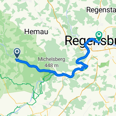
A cycling route starting in Riedenburg, Bavaria, Germany.
Overview
About this route
Two great beer gardens are located along the route.
In Kottingwörth, Gasthaus zur Sonne and in Deising, Gasthaus zum Himmelreich. - -:--
- Duration
- 18.9 km
- Distance
- 52 m
- Ascent
- 43 m
- Descent
- ---
- Avg. speed
- ---
- Max. altitude
Route quality
Waytypes & surfaces along the route
Waytypes
Track
16.6 km
(88 %)
Quiet road
1.5 km
(8 %)
Surfaces
Paved
4.7 km
(25 %)
Unpaved
14.2 km
(75 %)
Gravel
12.5 km
(66 %)
Asphalt
4.7 km
(25 %)
Loose gravel
1.7 km
(9 %)
Continue with Bikemap
Use, edit, or download this cycling route
You would like to ride Riedenburg/Kottingwörth or customize it for your own trip? Here is what you can do with this Bikemap route:
Free features
- Save this route as favorite or in collections
- Copy & plan your own version of this route
- Sync your route with Garmin or Wahoo
Premium features
Free trial for 3 days, or one-time payment. More about Bikemap Premium.
- Navigate this route on iOS & Android
- Export a GPX / KML file of this route
- Create your custom printout (try it for free)
- Download this route for offline navigation
Discover more Premium features.
Get Bikemap PremiumFrom our community
Other popular routes starting in Riedenburg
 Riedenburg-Donau-Kehlheim
- Distance
- 66.8 km
- Ascent
- 448 m
- Descent
- 445 m
- Location
- Riedenburg, Bavaria, Germany
 Tag 5 Riedenburg nach Nürnberg
- Distance
- 101.7 km
- Ascent
- 840 m
- Descent
- 854 m
- Location
- Riedenburg, Bavaria, Germany
 Riedenburg_Klamm_Burg Prunn_Mantelberg
- Distance
- 26.2 km
- Ascent
- 547 m
- Descent
- 547 m
- Location
- Riedenburg, Bavaria, Germany
 Riedenburg Kelheim Befreiungshalle Kloster Weltenburg
- Distance
- 45.8 km
- Ascent
- 255 m
- Descent
- 260 m
- Location
- Riedenburg, Bavaria, Germany
 Riedenburg - Regensburg
- Distance
- 53.4 km
- Ascent
- 144 m
- Descent
- 159 m
- Location
- Riedenburg, Bavaria, Germany
 Riedenburg-Schmbachtal-Kehlheim-Riedenburg
- Distance
- 47.6 km
- Ascent
- 372 m
- Descent
- 373 m
- Location
- Riedenburg, Bavaria, Germany
 D_Bayern_Riedenburg-SchlossPrunn-BurgRandeck-HolzbrückeTatzlwurm-Einthal-Klamm(50cm-schmaler Durchstieg-und-Steig)_RR-23km-600hm
- Distance
- 22.4 km
- Ascent
- 728 m
- Descent
- 728 m
- Location
- Riedenburg, Bavaria, Germany
 Riedenburg-Rundtour
- Distance
- 34.1 km
- Ascent
- 382 m
- Descent
- 382 m
- Location
- Riedenburg, Bavaria, Germany
Open it in the app