

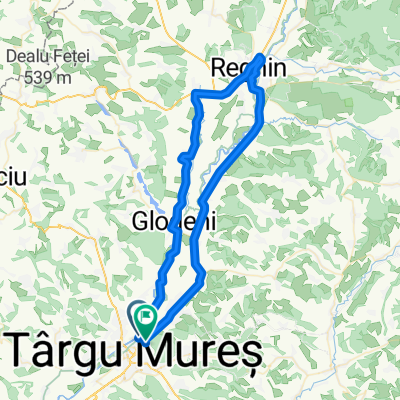
Targu-Mures - Corunca - Balauseri - Miercurea Nirajului - Targu-Mures
A cycling route starting in Sântana de Mureş, Mureș County, Romania.
Overview
About this route
Targu-Mures - Corunca - Balauseri - Miercurea Nirajului - Targu-Mures
- -:--
- Duration
- 74.8 km
- Distance
- 508 m
- Ascent
- 510 m
- Descent
- ---
- Avg. speed
- ---
- Max. altitude

Route quality
Waytypes & surfaces along the route
Waytypes
Cycleway
13.5 km
(18 %)
Quiet road
10.5 km
(14 %)
Surfaces
Paved
59.8 km
(80 %)
Unpaved
3 km
(4 %)
Asphalt
59.8 km
(80 %)
Unpaved (undefined)
1.5 km
(2 %)
Continue with Bikemap
Use, edit, or download this cycling route
You would like to ride Targu-Mures - Corunca - Balauseri - Miercurea Nirajului - Targu-Mures or customize it for your own trip? Here is what you can do with this Bikemap route:
Free features
- Save this route as favorite or in collections
- Copy & plan your own version of this route
- Sync your route with Garmin or Wahoo
Premium features
Free trial for 3 days, or one-time payment. More about Bikemap Premium.
- Navigate this route on iOS & Android
- Export a GPX / KML file of this route
- Create your custom printout (try it for free)
- Download this route for offline navigation
Discover more Premium features.
Get Bikemap PremiumFrom our community
Other popular routes starting in Sântana de Mureş
 2021.marc.21-135km
- Distance
- 135.6 km
- Ascent
- 1,304 m
- Descent
- 1,303 m
- Location
- Sântana de Mureş, Mureș County, Romania
 Brief bike tour from Sântana de Mureş to (null)
- Distance
- 6.9 km
- Ascent
- 13 m
- Descent
- 12 m
- Location
- Sântana de Mureş, Mureș County, Romania
 Targu-Mures - Livezeni - Miercurea Nirajului - Ungheni - Targu Mures
- Distance
- 64.5 km
- Ascent
- 184 m
- Descent
- 186 m
- Location
- Sântana de Mureş, Mureș County, Romania
 RemeteszegPanitSzCsaladTemplom
- Distance
- 23.2 km
- Ascent
- 170 m
- Descent
- 168 m
- Location
- Sântana de Mureş, Mureș County, Romania
 Targu-Mures - Corunca - Balauseri - Miercurea Nirajului - Targu-Mures
- Distance
- 74.8 km
- Ascent
- 508 m
- Descent
- 510 m
- Location
- Sântana de Mureş, Mureș County, Romania
 Régeni körút
- Distance
- 67.4 km
- Ascent
- 128 m
- Descent
- 119 m
- Location
- Sântana de Mureş, Mureș County, Romania
 Targu-Mures - Band - Iernut - Ungheni
- Distance
- 78 km
- Ascent
- 266 m
- Descent
- 266 m
- Location
- Sântana de Mureş, Mureș County, Romania
 tg-mures-bala-glodeni-santana
- Distance
- 47 km
- Ascent
- 329 m
- Descent
- 329 m
- Location
- Sântana de Mureş, Mureș County, Romania
Open it in the app