

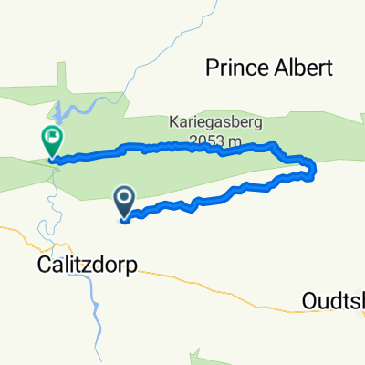
Calitzdorp-Ladismith
A cycling route starting in Calitzdorp, Western Cape, Republic of South Africa.
Overview
About this route
jhhhg
(cloned from route 2518209)- -:--
- Duration
- 48.8 km
- Distance
- 837 m
- Ascent
- 537 m
- Descent
- ---
- Avg. speed
- ---
- Max. altitude
Route quality
Waytypes & surfaces along the route
Waytypes
Quiet road
1.5 km
(3 %)
Undefined
47.4 km
(97 %)
Surfaces
Paved
48.4 km
(99 %)
Unpaved
0.5 km
(1 %)
Asphalt
47.9 km
(98 %)
Paved (undefined)
0.5 km
(1 %)
Unpaved (undefined)
0.5 km
(1 %)
Continue with Bikemap
Use, edit, or download this cycling route
You would like to ride Calitzdorp-Ladismith or customize it for your own trip? Here is what you can do with this Bikemap route:
Free features
- Save this route as favorite or in collections
- Copy & plan your own version of this route
- Sync your route with Garmin or Wahoo
Premium features
Free trial for 3 days, or one-time payment. More about Bikemap Premium.
- Navigate this route on iOS & Android
- Export a GPX / KML file of this route
- Create your custom printout (try it for free)
- Download this route for offline navigation
Discover more Premium features.
Get Bikemap PremiumFrom our community
Other popular routes starting in Calitzdorp
 Calitzdorp to Riversdale
- Distance
- 118.4 km
- Ascent
- 1,989 m
- Descent
- 2,122 m
- Location
- Calitzdorp, Western Cape, Republic of South Africa
 Calitzdorp-Ladismith
- Distance
- 48.8 km
- Ascent
- 837 m
- Descent
- 537 m
- Location
- Calitzdorp, Western Cape, Republic of South Africa
 Calitzdorp to Riversdale
- Distance
- 113.1 km
- Ascent
- 1,252 m
- Descent
- 1,317 m
- Location
- Calitzdorp, Western Cape, Republic of South Africa
 Die Hel to Dwyka river
- Distance
- 115.2 km
- Ascent
- 1,604 m
- Descent
- 1,534 m
- Location
- Calitzdorp, Western Cape, Republic of South Africa
 Karoo Crossing day 1
- Distance
- 86.5 km
- Ascent
- 1,699 m
- Descent
- 1,329 m
- Location
- Calitzdorp, Western Cape, Republic of South Africa
 Nelsrivier to bottom of Die Hel
- Distance
- 101.9 km
- Ascent
- 1,949 m
- Descent
- 1,976 m
- Location
- Calitzdorp, Western Cape, Republic of South Africa
 Gamkaskloof to Oudtshoorn
- Distance
- 94 km
- Ascent
- 1,596 m
- Descent
- 1,658 m
- Location
- Calitzdorp, Western Cape, Republic of South Africa
 Passes Tour 15
- Distance
- 56.6 km
- Ascent
- 1,636 m
- Descent
- 1,043 m
- Location
- Calitzdorp, Western Cape, Republic of South Africa
Open it in the app