

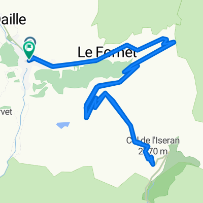
p30 Col de L'Iseran
A cycling route starting in Val d'Isère, Auvergne-Rhône-Alpes, France.
Overview
About this route
Col de L'Iseran 2770 m n.p.m.
Przejechałem 12.07.2014 z Bonneval-sur-Arc do Sainte-Foy-Tarentaise- -:--
- Duration
- 52.6 km
- Distance
- 1,078 m
- Ascent
- 1,819 m
- Descent
- ---
- Avg. speed
- ---
- Max. altitude

Route highlights
Points of interest along the route

Point of interest after 14 km
Col de L'Iseran 2770 m n.p.m. 12.07.2014
Continue with Bikemap
Use, edit, or download this cycling route
You would like to ride p30 Col de L'Iseran or customize it for your own trip? Here is what you can do with this Bikemap route:
Free features
- Save this route as favorite or in collections
- Copy & plan your own version of this route
- Sync your route with Garmin or Wahoo
Premium features
Free trial for 3 days, or one-time payment. More about Bikemap Premium.
- Navigate this route on iOS & Android
- Export a GPX / KML file of this route
- Create your custom printout (try it for free)
- Download this route for offline navigation
Discover more Premium features.
Get Bikemap PremiumFrom our community
Other popular routes starting in Val d'Isère
 Col de l'ISeran
- Distance
- 40.9 km
- Ascent
- 1,213 m
- Descent
- 1,209 m
- Location
- Val d'Isère, Auvergne-Rhône-Alpes, France
 Lanslevillard - Susa
- Distance
- 66.3 km
- Ascent
- 1,407 m
- Descent
- 2,382 m
- Location
- Val d'Isère, Auvergne-Rhône-Alpes, France
 3-Tag_ValD-isere-Valloire
- Distance
- 114.3 km
- Ascent
- 1,895 m
- Descent
- 2,305 m
- Location
- Val d'Isère, Auvergne-Rhône-Alpes, France
 5. Etappe Oberdiessbach Le Lavandou
- Distance
- 93.7 km
- Ascent
- 1,786 m
- Descent
- 2,892 m
- Location
- Val d'Isère, Auvergne-Rhône-Alpes, France
 Val D'Isere - Col d'Iseran - Col du Mont Cenis
- Distance
- 65.1 km
- Ascent
- 1,563 m
- Descent
- 1,917 m
- Location
- Val d'Isère, Auvergne-Rhône-Alpes, France
 Transalpine (12) Vijaron - St.Jean de Maurienne
- Distance
- 70.8 km
- Ascent
- 367 m
- Descent
- 1,553 m
- Location
- Val d'Isère, Auvergne-Rhône-Alpes, France
 Cols de Mont Cenis y Petit Mont Cenis
- Distance
- 47 km
- Ascent
- 1,108 m
- Descent
- 1,108 m
- Location
- Val d'Isère, Auvergne-Rhône-Alpes, France
 Alpencross 2007/4 - Bessans bis Frais
- Distance
- 74.6 km
- Ascent
- 2,291 m
- Descent
- 2,502 m
- Location
- Val d'Isère, Auvergne-Rhône-Alpes, France
Open it in the app