

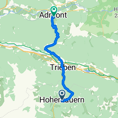
Route Robsi
A cycling route starting in Hohentauern, Styria, Austria.
Overview
About this route
lang und viel Höhenmeter mit einigen wilden Steigungen
- -:--
- Duration
- 159.4 km
- Distance
- 2,278 m
- Ascent
- 2,479 m
- Descent
- ---
- Avg. speed
- ---
- Max. altitude
Route quality
Waytypes & surfaces along the route
Waytypes
Busy road
106.8 km
(67 %)
Track
19.7 km
(12 %)
Surfaces
Paved
94.9 km
(60 %)
Unpaved
13.8 km
(9 %)
Asphalt
94.3 km
(59 %)
Gravel
8.2 km
(5 %)
Continue with Bikemap
Use, edit, or download this cycling route
You would like to ride Route Robsi or customize it for your own trip? Here is what you can do with this Bikemap route:
Free features
- Save this route as favorite or in collections
- Copy & plan your own version of this route
- Split it into stages to create a multi-day tour
- Sync your route with Garmin or Wahoo
Premium features
Free trial for 3 days, or one-time payment. More about Bikemap Premium.
- Navigate this route on iOS & Android
- Export a GPX / KML file of this route
- Create your custom printout (try it for free)
- Download this route for offline navigation
Discover more Premium features.
Get Bikemap PremiumFrom our community
Other popular routes starting in Hohentauern
 Brodjäger Weg nach Bergmanngasse 6, Trieben
- Distance
- 4.9 km
- Ascent
- 8 m
- Descent
- 208 m
- Location
- Hohentauern, Styria, Austria
 Hohentauern - LZL
- Distance
- 135.6 km
- Ascent
- 1,718 m
- Descent
- 1,894 m
- Location
- Hohentauern, Styria, Austria
 Tauernstraße 15, Hohentauern nach Wiener Straße 5, Friesach
- Distance
- 82 km
- Ascent
- 421 m
- Descent
- 1,054 m
- Location
- Hohentauern, Styria, Austria
 Alpes-Autumn-CC -- Trieben - Linz 142km REC-Stage
- Distance
- 152.9 km
- Ascent
- 465 m
- Descent
- 1,394 m
- Location
- Hohentauern, Styria, Austria
 Route Robsi
- Distance
- 159.4 km
- Ascent
- 2,278 m
- Descent
- 2,479 m
- Location
- Hohentauern, Styria, Austria
 Hohentauern-Admont
- Distance
- 23.8 km
- Ascent
- 434 m
- Descent
- 1,059 m
- Location
- Hohentauern, Styria, Austria
 Hohe Tauern über Oberzeiring,niederwölz,scheifling pöls,Hohetauern
- Distance
- 145.2 km
- Ascent
- 997 m
- Descent
- 1,476 m
- Location
- Hohentauern, Styria, Austria
 Hohentauern 168 do Hohentauern 168
- Distance
- 13.8 km
- Ascent
- 280 m
- Descent
- 296 m
- Location
- Hohentauern, Styria, Austria
Open it in the app