

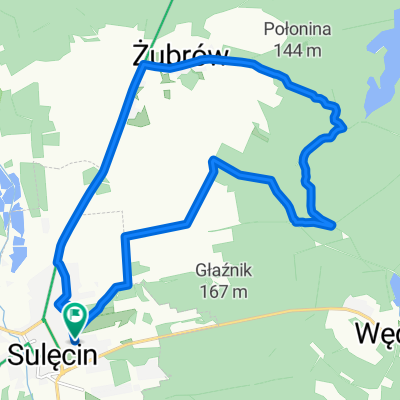
Brzeźno
A cycling route starting in Sulęcin, Lesser Poland Voivodeship, Poland.
Overview
About this route
Sulęcin - Ostrów - Brzeźno - Sulęcin
- -:--
- Duration
- 12.8 km
- Distance
- 127 m
- Ascent
- 129 m
- Descent
- ---
- Avg. speed
- ---
- Max. altitude
Route quality
Waytypes & surfaces along the route
Waytypes
Track
5.9 km
(46 %)
Busy road
3 km
(23 %)
Surfaces
Paved
4.5 km
(35 %)
Unpaved
0.6 km
(5 %)
Asphalt
4.4 km
(34 %)
Gravel
0.6 km
(5 %)
Continue with Bikemap
Use, edit, or download this cycling route
You would like to ride Brzeźno or customize it for your own trip? Here is what you can do with this Bikemap route:
Free features
- Save this route as favorite or in collections
- Copy & plan your own version of this route
- Sync your route with Garmin or Wahoo
Premium features
Free trial for 3 days, or one-time payment. More about Bikemap Premium.
- Navigate this route on iOS & Android
- Export a GPX / KML file of this route
- Create your custom printout (try it for free)
- Download this route for offline navigation
Discover more Premium features.
Get Bikemap PremiumFrom our community
Other popular routes starting in Sulęcin
 Wąwóz 2
- Distance
- 16 km
- Ascent
- 145 m
- Descent
- 142 m
- Location
- Sulęcin, Lesser Poland Voivodeship, Poland
 Brzeźno
- Distance
- 12.8 km
- Ascent
- 127 m
- Descent
- 129 m
- Location
- Sulęcin, Lesser Poland Voivodeship, Poland
 Żubrów 3
- Distance
- 20.5 km
- Ascent
- 203 m
- Descent
- 201 m
- Location
- Sulęcin, Lesser Poland Voivodeship, Poland
 Bory Postomskie - XXVI MZC
- Distance
- 19.5 km
- Ascent
- 196 m
- Descent
- 195 m
- Location
- Sulęcin, Lesser Poland Voivodeship, Poland
 Wąwóz
Wąwóz- Distance
- 14.4 km
- Ascent
- 152 m
- Descent
- 153 m
- Location
- Sulęcin, Lesser Poland Voivodeship, Poland
 Wyścig szosowy - Sulęcin / Wyścig szosowy - Sulęcin | Strava Ride Segment in Sulęcin, lubuskie, Poland
- Distance
- 26.7 km
- Ascent
- 276 m
- Descent
- 209 m
- Location
- Sulęcin, Lesser Poland Voivodeship, Poland
 Żubrów
- Distance
- 42.1 km
- Ascent
- 412 m
- Descent
- 409 m
- Location
- Sulęcin, Lesser Poland Voivodeship, Poland
 Brzeźno 2
- Distance
- 20.9 km
- Ascent
- 181 m
- Descent
- 183 m
- Location
- Sulęcin, Lesser Poland Voivodeship, Poland
Open it in the app