na SMRK přes Ramzovou, pod Obřími skálami, Horní Lipovou, Paprsek, St. Město
- 62.7 km
- 1,393 m
- 1,346 m
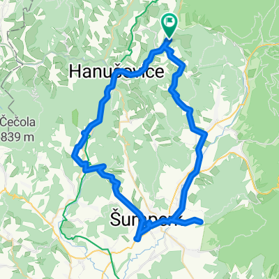
- Hanušovice, Olomoucký kraj, Czechia
A cycling route starting in Hanušovice, Olomoucký kraj, Czechia.
Overview
A little-known, but all the more interesting route, leading partly along the ridge. Hanusovice, Pusté Žibřidovice, old military road, Mokřiny (2 km from Sušina), U 7 cest, Pod Bubuší, above the lift, below Kralický Sněžník, Horní and Dolní Morava and back. Relatively good roads both up and down - asphalt (old military road from the end of the First Republic - bunkers), fortified along the ridge. BEST TO RIDE FIRST TO DOLNÍ MORAVA
created this 16 years ago
Route quality
Track
36.7 km
(51 %)
Road
13 km
(18 %)
Paved
35.3 km
(49 %)
Unpaved
18 km
(25 %)
Asphalt
21.6 km
(30 %)
Gravel
14.4 km
(20 %)
Route highlights
Občerstvení iubytování ÚSVIT, Vysoké Žibřidovice.
Pramen, odpočívadlo
Cca. 2 km nahoru (ne moc do kopce) vrchol Sušiny (1.312 m/m), necelý 1 km řada bunkrů (už na hřebenu).
Mokřiny
Odpočívado u Sedmi cest. Dolů po asfaltce zkratka směr Vojtíškov a hl. cesta Králiky - Hanušovice.
Pod Babuší - odpočívadlo.
Směr dolů - zkratka na Malou Moravu (hl. silnice)
výhled
Mromaorový lom. Horní Morava.Občerstvení.
Občerstvení.
Malá Morava, občerstvení.
rybník
Cca 250 m. Josefová, památný strom(y).
potok Hůčava
Volská louka
Banja Luka
Continue with Bikemap
You would like to ride masivem Kralického Sněžníku s <°((()>< Wandou or customize it for your own trip? Here is what you can do with this Bikemap route:
Free trial for 3 days, or one-time payment. More about Bikemap Premium.
Discover more Premium features.
Get Bikemap PremiumFrom our community
Open it in the app