

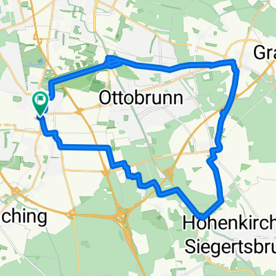
Schönste Runde im Münchner Süden
A cycling route starting in Unterhaching, Bavaria, Germany.
Overview
About this route
Among the thousand possible routes in the southern Munich area, this one offers the most postcard scenes, views, and authentic villages. Largely low traffic.
- -:--
- Duration
- 61 km
- Distance
- 343 m
- Ascent
- 302 m
- Descent
- ---
- Avg. speed
- ---
- Max. altitude
Route quality
Waytypes & surfaces along the route
Waytypes
Quiet road
47.6 km
(78 %)
Track
4.9 km
(8 %)
Surfaces
Paved
59.8 km
(98 %)
Asphalt
59.8 km
(98 %)
Undefined
1.2 km
(2 %)
Continue with Bikemap
Use, edit, or download this cycling route
You would like to ride Schönste Runde im Münchner Süden or customize it for your own trip? Here is what you can do with this Bikemap route:
Free features
- Save this route as favorite or in collections
- Copy & plan your own version of this route
- Sync your route with Garmin or Wahoo
Premium features
Free trial for 3 days, or one-time payment. More about Bikemap Premium.
- Navigate this route on iOS & Android
- Export a GPX / KML file of this route
- Create your custom printout (try it for free)
- Download this route for offline navigation
Discover more Premium features.
Get Bikemap PremiumFrom our community
Other popular routes starting in Unterhaching
 ala Sabrina München- Bad Tölz- München
- Distance
- 105.1 km
- Ascent
- 499 m
- Descent
- 499 m
- Location
- Unterhaching, Bavaria, Germany
 200km + Klettertour
- Distance
- 203.6 km
- Ascent
- 1,284 m
- Descent
- 1,235 m
- Location
- Unterhaching, Bavaria, Germany
 rundtour Putzbrunn
- Distance
- 25.3 km
- Ascent
- 33 m
- Descent
- 31 m
- Location
- Unterhaching, Bavaria, Germany
 Perlacher Forst nach Bad Tölz
- Distance
- 87 km
- Ascent
- 416 m
- Descent
- 414 m
- Location
- Unterhaching, Bavaria, Germany
 Münchner Feierabendrunde
- Distance
- 42 km
- Ascent
- 311 m
- Descent
- 311 m
- Location
- Unterhaching, Bavaria, Germany
 Münchner Forste-Gleißental-Trailtour
- Distance
- 35.5 km
- Ascent
- 87 m
- Descent
- 88 m
- Location
- Unterhaching, Bavaria, Germany
 Feierabendrunde: Ludwigshöhe
- Distance
- 36.6 km
- Ascent
- 188 m
- Descent
- 200 m
- Location
- Unterhaching, Bavaria, Germany
 Perlacher Forst - Ascholding
- Distance
- 67.7 km
- Ascent
- 485 m
- Descent
- 463 m
- Location
- Unterhaching, Bavaria, Germany
Open it in the app