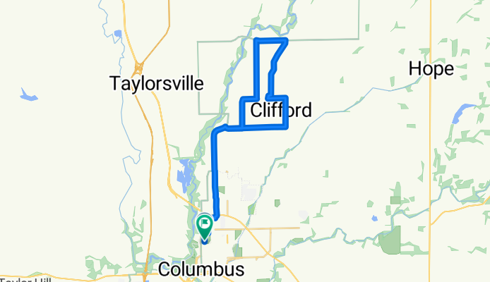
Su Casa Benefit Ride
A cycling route starting in Columbus, Indiana, United States of America.
Overview
About this route
20 mile benefit ride for Su Casa
- -:--
- Duration
- 33.2 km
- Distance
- 8 m
- Ascent
- 8 m
- Descent
- ---
- Avg. speed
- ---
- Avg. speed
Route quality
Waytypes & surfaces along the route
Waytypes
Road
13.5 km
(41 %)
Cycleway
8.6 km
(26 %)
Surfaces
Paved
10.6 km
(32 %)
Asphalt
9.4 km
(28 %)
Concrete
1.2 km
(4 %)
Undefined
22.6 km
(68 %)
Continue with Bikemap
Use, edit, or download this cycling route
You would like to ride Su Casa Benefit Ride or customize it for your own trip? Here is what you can do with this Bikemap route:
Free features
- Save this route as favorite or in collections
- Copy & plan your own version of this route
- Sync your route with Garmin or Wahoo
Premium features
Free trial for 3 days, or one-time payment. More about Bikemap Premium.
- Navigate this route on iOS & Android
- Export a GPX / KML file of this route
- Create your custom printout (try it for free)
- Download this route for offline navigation
Discover more Premium features.
Get Bikemap PremiumFrom our community
Other popular routes starting in Columbus
- 506 Fifth St, Columbus to 506 Fifth St, Columbus
- Distance
- 9.6 km
- Ascent
- 25 m
- Descent
- 23 m
- Location
- Columbus, Indiana, United States of America
- MillRace Route
- Distance
- 6.3 km
- Ascent
- 22 m
- Descent
- 22 m
- Location
- Columbus, Indiana, United States of America
- CCE 1: Clifty Creek Elementary 21 miles - CCE 1: Clifty Creek Elementary 21 miles
- Distance
- 33.4 km
- Ascent
- 75 m
- Descent
- 76 m
- Location
- Columbus, Indiana, United States of America
- Su Casa Benefit Ride
- Distance
- 33.2 km
- Ascent
- 8 m
- Descent
- 8 m
- Location
- Columbus, Indiana, United States of America
- 39.193° N -85.977° W to 39.371° N -86.213° W
- Distance
- 170.1 km
- Ascent
- 1,552 m
- Descent
- 1,531 m
- Location
- Columbus, Indiana, United States of America
- Tour de Temple Day 1
- Distance
- 89 km
- Ascent
- 878 m
- Descent
- 852 m
- Location
- Columbus, Indiana, United States of America
- Will HBB Marking
- Distance
- 63.6 km
- Ascent
- 408 m
- Descent
- 411 m
- Location
- Columbus, Indiana, United States of America
- Columbus, IN People's Trail
- Distance
- 34.6 km
- Ascent
- 38 m
- Descent
- 38 m
- Location
- Columbus, Indiana, United States of America
Open it in the app