

Col du Mont-Cenis
A cycling route starting in Bussoleno, Piedmont, Italy.
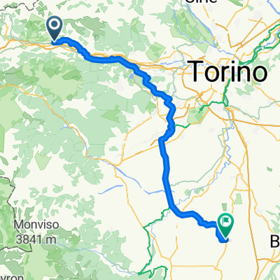
Overview
About this route
From the Susa Valley to Lake Mont Cenis.
- -:--
- Duration
- 37.9 km
- Distance
- 1,709 m
- Ascent
- 66 m
- Descent
- ---
- Avg. speed
- ---
- Max. altitude

Route quality
Waytypes & surfaces along the route
Waytypes
Quiet road
4.6 km
(12 %)
Track
0.8 km
(2 %)
Surfaces
Paved
37.2 km
(98 %)
Unpaved
0.8 km
(2 %)
Asphalt
37.2 km
(98 %)
Gravel
0.8 km
(2 %)
Continue with Bikemap
Use, edit, or download this cycling route
You would like to ride Col du Mont-Cenis or customize it for your own trip? Here is what you can do with this Bikemap route:
Free features
- Save this route as favorite or in collections
- Copy & plan your own version of this route
- Sync your route with Garmin or Wahoo
Premium features
Free trial for 3 days, or one-time payment. More about Bikemap Premium.
- Navigate this route on iOS & Android
- Export a GPX / KML file of this route
- Create your custom printout (try it for free)
- Download this route for offline navigation
Discover more Premium features.
Get Bikemap PremiumFrom our community
Other popular routes starting in Bussoleno
 Bussoleno Giaveno
- Distance
- 70.5 km
- Ascent
- 427 m
- Descent
- 426 m
- Location
- Bussoleno, Piedmont, Italy
 ALP45 susa
- Distance
- 77 km
- Ascent
- 3,237 m
- Descent
- 3,337 m
- Location
- Bussoleno, Piedmont, Italy
 Busoleno Finestre Sestriere Cesana
- Distance
- 63.8 km
- Ascent
- 2,402 m
- Descent
- 1,486 m
- Location
- Bussoleno, Piedmont, Italy
 Moncenisio
- Distance
- 33.3 km
- Ascent
- 1,689 m
- Descent
- 40 m
- Location
- Bussoleno, Piedmont, Italy
 Da Via Rocca 12, Bussoleno a Lungo Dora Pietro Colletta 111, Torino
- Distance
- 54.6 km
- Ascent
- 249 m
- Descent
- 480 m
- Location
- Bussoleno, Piedmont, Italy
 Bussoleno - Cavallermaggiore
- Distance
- 92.1 km
- Ascent
- 451 m
- Descent
- 611 m
- Location
- Bussoleno, Piedmont, Italy
 Col du Mont-Cenis
- Distance
- 37.9 km
- Ascent
- 1,709 m
- Descent
- 66 m
- Location
- Bussoleno, Piedmont, Italy
 rif trucco
- Distance
- 25.4 km
- Ascent
- 1,303 m
- Descent
- 19 m
- Location
- Bussoleno, Piedmont, Italy
Open it in the app