

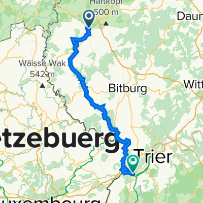
2014 Pronsfeld-Alfbachtal
A cycling route starting in Pronsfeld, Rhineland-Palatinate, Germany.
Overview
About this route
kurzen abstecher bis habscheider mühle bis unter die autobahn und zurück,auch ne bahntrasse,das tal still und schön aber auch nicht spektakulär
- -:--
- Duration
- 13.6 km
- Distance
- 120 m
- Ascent
- 120 m
- Descent
- ---
- Avg. speed
- ---
- Max. altitude
Route quality
Waytypes & surfaces along the route
Waytypes
Track
8.2 km
(60 %)
Path
2.8 km
(21 %)
Surfaces
Paved
12.7 km
(93 %)
Asphalt
12.7 km
(93 %)
Undefined
0.9 km
(7 %)
Continue with Bikemap
Use, edit, or download this cycling route
You would like to ride 2014 Pronsfeld-Alfbachtal or customize it for your own trip? Here is what you can do with this Bikemap route:
Free features
- Save this route as favorite or in collections
- Copy & plan your own version of this route
- Sync your route with Garmin or Wahoo
Premium features
Free trial for 3 days, or one-time payment. More about Bikemap Premium.
- Navigate this route on iOS & Android
- Export a GPX / KML file of this route
- Create your custom printout (try it for free)
- Download this route for offline navigation
Discover more Premium features.
Get Bikemap PremiumFrom our community
Other popular routes starting in Pronsfeld
 Pronsfeld-Prüm
- Distance
- 9.5 km
- Ascent
- 94 m
- Descent
- 47 m
- Location
- Pronsfeld, Rhineland-Palatinate, Germany
 2014 Pronsfeld-Alfbachtal
- Distance
- 13.6 km
- Ascent
- 120 m
- Descent
- 120 m
- Location
- Pronsfeld, Rhineland-Palatinate, Germany
 Pronsfeld - Bütgenbach
- Distance
- 53.5 km
- Ascent
- 645 m
- Descent
- 454 m
- Location
- Pronsfeld, Rhineland-Palatinate, Germany
 EIFEL - PRONSFELD-NEUERBURG
- Distance
- 24.2 km
- Ascent
- 238 m
- Descent
- 280 m
- Location
- Pronsfeld, Rhineland-Palatinate, Germany
 Von Pronsfeld nach St Vith
- Distance
- 27.9 km
- Ascent
- 389 m
- Descent
- 301 m
- Location
- Pronsfeld, Rhineland-Palatinate, Germany
 Abendrunde
- Distance
- 33 km
- Ascent
- 340 m
- Descent
- 340 m
- Location
- Pronsfeld, Rhineland-Palatinate, Germany
 Alferweg 13, Pronsfeld nach Steinackerring 33, Bleialf
- Distance
- 17.9 km
- Ascent
- 315 m
- Descent
- 261 m
- Location
- Pronsfeld, Rhineland-Palatinate, Germany
 Pronsfeld-Wasserbillig
- Distance
- 85 km
- Ascent
- 361 m
- Descent
- 592 m
- Location
- Pronsfeld, Rhineland-Palatinate, Germany
Open it in the app