

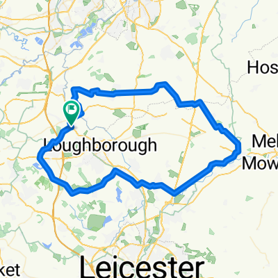
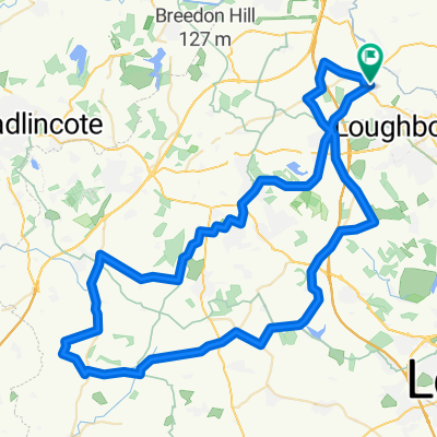
Loughborough - St Josephs CAKE loop
A cycling route starting in Hathern, England, United Kingdom.
Overview
About this route
<span class="description">This route has a stretch of Bridleway which involves crossing a couple of fields. Mountain bikes will handle this stretch well or you can do what we did - got off and walked! One of the fields has a very friendly horse in it so take an apple with you just incase she's there :) The views from the top of LubCloud Hill were lovely so worth the uphill struggle! A lovely stop at St Josephs tea room for cake and then you can wind your way back. You can also visit St Bernards monastery if you wanted to.</span>
- -:--
- Duration
- 22 km
- Distance
- 205 m
- Ascent
- 206 m
- Descent
- ---
- Avg. speed
- ---
- Max. altitude
Route quality
Waytypes & surfaces along the route
Waytypes
Road
7.5 km
(34 %)
Quiet road
4 km
(18 %)
Surfaces
Paved
7 km
(32 %)
Unpaved
3.3 km
(15 %)
Asphalt
6.8 km
(31 %)
Gravel
2.2 km
(10 %)
Continue with Bikemap
Use, edit, or download this cycling route
You would like to ride Loughborough - St Josephs CAKE loop or customize it for your own trip? Here is what you can do with this Bikemap route:
Free features
- Save this route as favorite or in collections
- Copy & plan your own version of this route
- Sync your route with Garmin or Wahoo
Premium features
Free trial for 3 days, or one-time payment. More about Bikemap Premium.
- Navigate this route on iOS & Android
- Export a GPX / KML file of this route
- Create your custom printout (try it for free)
- Download this route for offline navigation
Discover more Premium features.
Get Bikemap PremiumFrom our community
Other popular routes starting in Hathern
 Loughborough - St Josephs CAKE loop
- Distance
- 22 km
- Ascent
- 205 m
- Descent
- 206 m
- Location
- Hathern, England, United Kingdom
 Loughborough - Sileby CAKE loop
- Distance
- 29.1 km
- Ascent
- 106 m
- Descent
- 106 m
- Location
- Hathern, England, United Kingdom
 Zouch Loop 3
- Distance
- 63.6 km
- Ascent
- 385 m
- Descent
- 384 m
- Location
- Hathern, England, United Kingdom
 Zouch Loop 1
- Distance
- 48.9 km
- Ascent
- 393 m
- Descent
- 392 m
- Location
- Hathern, England, United Kingdom
 P2L June
- Distance
- 100.6 km
- Ascent
- 495 m
- Descent
- 506 m
- Location
- Hathern, England, United Kingdom
 P2L May18
- Distance
- 69.9 km
- Ascent
- 352 m
- Descent
- 352 m
- Location
- Hathern, England, United Kingdom
 Harvey's Coffee Cabin trip
- Distance
- 73.9 km
- Ascent
- 418 m
- Descent
- 418 m
- Location
- Hathern, England, United Kingdom
 Zouch loop 2
- Distance
- 32.8 km
- Ascent
- 128 m
- Descent
- 127 m
- Location
- Hathern, England, United Kingdom
Open it in the app