

Best Pub Crawl Ever
A cycling route starting in Thatcham, England, United Kingdom.
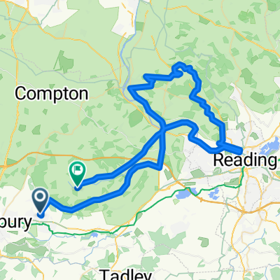
Overview
About this route
Pub Crawl
- -:--
- Duration
- 24.1 km
- Distance
- 166 m
- Ascent
- 157 m
- Descent
- ---
- Avg. speed
- ---
- Max. altitude
Route highlights
Points of interest along the route
Point of interest after 3.8 km
The cottage
Point of interest after 7.1 km
Coach and Horses
Point of interest after 10.1 km
The rowbarge
Point of interest after 10.4 km
The Angel
Point of interest after 14.1 km
Butt Inn
Point of interest after 17.1 km
The winning hand
Point of interest after 19.6 km
The Queen's Head
Point of interest after 22.2 km
The Boot
Point of interest after 22.3 km
The Bull
Point of interest after 24.1 km
The Bladebone
Continue with Bikemap
Use, edit, or download this cycling route
You would like to ride Best Pub Crawl Ever or customize it for your own trip? Here is what you can do with this Bikemap route:
Free features
- Save this route as favorite or in collections
- Copy & plan your own version of this route
- Sync your route with Garmin or Wahoo
Premium features
Free trial for 3 days, or one-time payment. More about Bikemap Premium.
- Navigate this route on iOS & Android
- Export a GPX / KML file of this route
- Create your custom printout (try it for free)
- Download this route for offline navigation
Discover more Premium features.
Get Bikemap PremiumFrom our community
Other popular routes starting in Thatcham
 The Block
- Distance
- 9.9 km
- Ascent
- 41 m
- Descent
- 44 m
- Location
- Thatcham, England, United Kingdom
 Recovered Route
- Distance
- 72.1 km
- Ascent
- 2,145 m
- Descent
- 2,170 m
- Location
- Thatcham, England, United Kingdom
 Best Pub Crawl Ever
- Distance
- 24.1 km
- Ascent
- 166 m
- Descent
- 157 m
- Location
- Thatcham, England, United Kingdom
 Thatcham - Amesbury - Stonehenge
- Distance
- 63 km
- Ascent
- 302 m
- Descent
- 292 m
- Location
- Thatcham, England, United Kingdom
 the 2.69 mile route in thatcham
- Distance
- 4.3 km
- Ascent
- 35 m
- Descent
- 33 m
- Location
- Thatcham, England, United Kingdom
 Fox & Dog - Coombe to Hannington via Wayfairers Walk
- Distance
- 66.4 km
- Ascent
- 1,538 m
- Descent
- 1,538 m
- Location
- Thatcham, England, United Kingdom
 Kennet & Avon Canal
- Distance
- 97.9 km
- Ascent
- 258 m
- Descent
- 306 m
- Location
- Thatcham, England, United Kingdom
 Muddy Lane, West Berkshire to 15 Rhigos, Reading
- Distance
- 28.3 km
- Ascent
- 87 m
- Descent
- 108 m
- Location
- Thatcham, England, United Kingdom
Open it in the app