

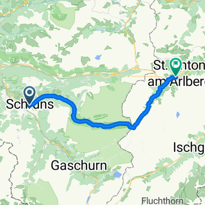
Übersgebirgradln 6: Schruns - Silbertal - St. Anton
A cycling route starting in Bartholomäberg, Vorarlberg, Austria.
Overview
About this route
Schruns - Hasahüsli - Silbertal - Obere Freschalpe (Hochmoor) - Langsee - Silbertaler Winterjöchl - St. Anton
- -:--
- Duration
- 37.4 km
- Distance
- 1,496 m
- Ascent
- 731 m
- Descent
- ---
- Avg. speed
- 1,952 m
- Max. altitude
Route quality
Waytypes & surfaces along the route
Waytypes
Track
22.4 km
(60 %)
Quiet road
5.2 km
(14 %)
Surfaces
Paved
15 km
(40 %)
Unpaved
19.8 km
(53 %)
Gravel
17.2 km
(46 %)
Asphalt
11.6 km
(31 %)
Continue with Bikemap
Use, edit, or download this cycling route
You would like to ride Übersgebirgradln 6: Schruns - Silbertal - St. Anton or customize it for your own trip? Here is what you can do with this Bikemap route:
Free features
- Save this route as favorite or in collections
- Copy & plan your own version of this route
- Sync your route with Garmin or Wahoo
Premium features
Free trial for 3 days, or one-time payment. More about Bikemap Premium.
- Navigate this route on iOS & Android
- Export a GPX / KML file of this route
- Create your custom printout (try it for free)
- Download this route for offline navigation
Discover more Premium features.
Get Bikemap PremiumFrom our community
Other popular routes starting in Bartholomäberg
 Silvretta-Arlbeg-Runde
- Distance
- 136.5 km
- Ascent
- 2,220 m
- Descent
- 2,220 m
- Location
- Bartholomäberg, Vorarlberg, Austria
 Übersgebirgradln 6: Schruns - Silbertal - St. Anton
- Distance
- 37.4 km
- Ascent
- 1,496 m
- Descent
- 731 m
- Location
- Bartholomäberg, Vorarlberg, Austria
 schruns mtb
- Distance
- 30 km
- Ascent
- 1,683 m
- Descent
- 1,683 m
- Location
- Bartholomäberg, Vorarlberg, Austria
 Me - Montafoner E-Bike Genuss Runde
- Distance
- 38.4 km
- Ascent
- 1,216 m
- Descent
- 1,216 m
- Location
- Bartholomäberg, Vorarlberg, Austria
 Schruns, Silbertalrunde
- Distance
- 29.3 km
- Ascent
- 870 m
- Descent
- 887 m
- Location
- Bartholomäberg, Vorarlberg, Austria
 schruns-heilbronnen hutte-silbertal
- Distance
- 63.1 km
- Ascent
- 1,722 m
- Descent
- 1,680 m
- Location
- Bartholomäberg, Vorarlberg, Austria
 Bartholomähberg, Kristberg
- Distance
- 17.4 km
- Ascent
- 558 m
- Descent
- 558 m
- Location
- Bartholomäberg, Vorarlberg, Austria
 Zeinisjoch
- Distance
- 61.6 km
- Ascent
- 1,652 m
- Descent
- 1,291 m
- Location
- Bartholomäberg, Vorarlberg, Austria
Open it in the app