

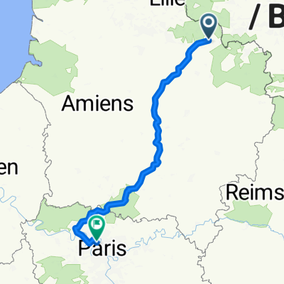
Valenciennes- Cambrai
A cycling route starting in Valenciennes, Hauts-de-France, France.
Overview
About this route
Forste okt i Frankrike
(cloned from route 2786506) (cloned from route 2786508)- -:--
- Duration
- 55.2 km
- Distance
- 176 m
- Ascent
- 154 m
- Descent
- ---
- Avg. speed
- ---
- Max. altitude

Route quality
Waytypes & surfaces along the route
Waytypes
Road
27.9 km
(51 %)
Busy road
15.3 km
(28 %)
Surfaces
Paved
13.4 km
(24 %)
Asphalt
12.9 km
(23 %)
Paving stones
0.3 km
(<1 %)
Continue with Bikemap
Use, edit, or download this cycling route
You would like to ride Valenciennes- Cambrai or customize it for your own trip? Here is what you can do with this Bikemap route:
Free features
- Save this route as favorite or in collections
- Copy & plan your own version of this route
- Sync your route with Garmin or Wahoo
Premium features
Free trial for 3 days, or one-time payment. More about Bikemap Premium.
- Navigate this route on iOS & Android
- Export a GPX / KML file of this route
- Create your custom printout (try it for free)
- Download this route for offline navigation
Discover more Premium features.
Get Bikemap PremiumFrom our community
Other popular routes starting in Valenciennes
 Autour de St Amand les Eaux
- Distance
- 64.8 km
- Ascent
- 135 m
- Descent
- 135 m
- Location
- Valenciennes, Hauts-de-France, France
 LILLE PARIS J1 - Lille - Bapaume + LILLE PARIS J2 - Bapaume - Lacroix-Saint-Ouen + LILLE PARIS J3 - Lacroix-Saint-Ouen - Asnières sur Seine
- Distance
- 277.4 km
- Ascent
- 1,282 m
- Descent
- 1,277 m
- Location
- Valenciennes, Hauts-de-France, France
 Etappe 4.2: Valenciennes - Chimay
- Distance
- 81.4 km
- Ascent
- 399 m
- Descent
- 190 m
- Location
- Valenciennes, Hauts-de-France, France
 13102018
- Distance
- 51.1 km
- Ascent
- 212 m
- Descent
- 212 m
- Location
- Valenciennes, Hauts-de-France, France
 Valenciennes to Noyon
- Distance
- 106.8 km
- Ascent
- 344 m
- Descent
- 326 m
- Location
- Valenciennes, Hauts-de-France, France
 14102018
- Distance
- 64.1 km
- Ascent
- 152 m
- Descent
- 155 m
- Location
- Valenciennes, Hauts-de-France, France
 Gravel 04042018
- Distance
- 53.5 km
- Ascent
- 161 m
- Descent
- 161 m
- Location
- Valenciennes, Hauts-de-France, France
 De Rue du Jolimetz 59, Valenciennes à Rue François Colliez 2, Valenciennes
- Distance
- 27.1 km
- Ascent
- 75 m
- Descent
- 74 m
- Location
- Valenciennes, Hauts-de-France, France
Open it in the app