

RTF-Strecke 111 km Eintracht Emmerich
A cycling route starting in Emmerich, North Rhine-Westphalia, Germany.
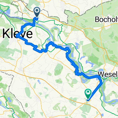
Overview
About this route
Circuit of approximately 111 km. It is ridden once a year for a Rad-Touren-Fahrt (RTF) organized by the cycling department of Eintracht Emmerich. Start and finish is at the sports ground at the corner of Eltener Str. (B8) and Borgheeser Weg. Predominantly flat course. The few hills are mostly between km 5 and km 30. Afterwards, the Rhine bridges in Rees and Emmerich are the highest elevations on the route. The wind, which very often blows from the southwest, should not be underestimated. After the start, the three control points are located in:
- Zeddam (NL), Koningsstraat,
- Millingen (D), Bruchstraße and in
- Appeldorn (D), Appeldorner Str.
- -:--
- Duration
- 100.9 km
- Distance
- 136 m
- Ascent
- 136 m
- Descent
- ---
- Avg. speed
- ---
- Max. altitude
Route highlights
Points of interest along the route
Point of interest after 26.5 km
Kontrolle 1
Point of interest after 55.6 km
Kontrolle 2
Point of interest after 82.8 km
Kontrolle 3
Point of interest after 100.9 km
Start und Ziel
Continue with Bikemap
Use, edit, or download this cycling route
You would like to ride RTF-Strecke 111 km Eintracht Emmerich or customize it for your own trip? Here is what you can do with this Bikemap route:
Free features
- Save this route as favorite or in collections
- Copy & plan your own version of this route
- Split it into stages to create a multi-day tour
- Sync your route with Garmin or Wahoo
Premium features
Free trial for 3 days, or one-time payment. More about Bikemap Premium.
- Navigate this route on iOS & Android
- Export a GPX / KML file of this route
- Create your custom printout (try it for free)
- Download this route for offline navigation
Discover more Premium features.
Get Bikemap PremiumFrom our community
Other popular routes starting in Emmerich
 1997_Rhein III (Niederrhein) (Emmerich - Xanten - Düsseldorf - Köln - Mainz - Pfungstadt)
- Distance
- 433.6 km
- Ascent
- 829 m
- Descent
- 758 m
- Location
- Emmerich, North Rhine-Westphalia, Germany
 1. Tag Emmerich-Grieth-Xanten-Rees-Emmerich
- Distance
- 75.4 km
- Ascent
- 108 m
- Descent
- 108 m
- Location
- Emmerich, North Rhine-Westphalia, Germany
 RTF-Strecke 111 km Eintracht Emmerich
- Distance
- 100.9 km
- Ascent
- 136 m
- Descent
- 136 m
- Location
- Emmerich, North Rhine-Westphalia, Germany
 Rund um Emmerich
- Distance
- 46.2 km
- Ascent
- 265 m
- Descent
- 276 m
- Location
- Emmerich, North Rhine-Westphalia, Germany
 Leichte Hügeltour rund um 's Heerenberg (NL)
- Distance
- 40 km
- Ascent
- 200 m
- Descent
- 200 m
- Location
- Emmerich, North Rhine-Westphalia, Germany
 NL171: 't Gelders Eiland - ab/bis Elten
- Distance
- 27.4 km
- Ascent
- 44 m
- Descent
- 44 m
- Location
- Emmerich, North Rhine-Westphalia, Germany
 14.07.29 Emmerich a. Rhein-Alpen
- Distance
- 79.2 km
- Ascent
- 49 m
- Descent
- 50 m
- Location
- Emmerich, North Rhine-Westphalia, Germany
 2. Tag Emmerich-Tolkamer-Millingen-Nijmegen-Elten-Emmerich
- Distance
- 75.3 km
- Ascent
- 180 m
- Descent
- 181 m
- Location
- Emmerich, North Rhine-Westphalia, Germany
Open it in the app