

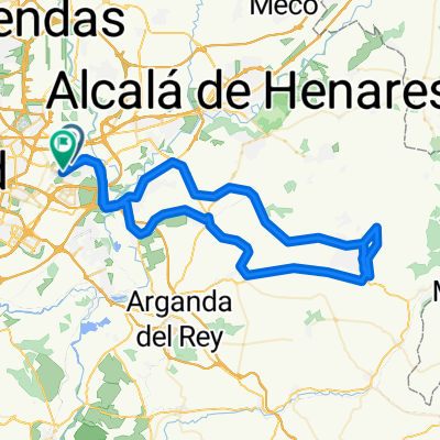
20140907 El Atazar
A cycling route starting in Coslada, Madrid, Spain.
Overview
About this route
estrin
with Manu, Pedro el Grande, Juan Pozo, José Tirones, Javi Hernández, Pedro Hijo, Antonio Cancellara, José el Cristalero, Paco Beteta, Pedro Padre, Mauri, Paco Cerro, José Luis El Maestro and Gabi.
- -:--
- Duration
- 141.2 km
- Distance
- 728 m
- Ascent
- 781 m
- Descent
- ---
- Avg. speed
- ---
- Max. altitude

Route quality
Waytypes & surfaces along the route
Waytypes
Road
31.1 km
(22 %)
Track
12.7 km
(9 %)
Surfaces
Paved
21.2 km
(15 %)
Unpaved
11.3 km
(8 %)
Asphalt
21.2 km
(15 %)
Gravel
5.6 km
(4 %)
Continue with Bikemap
Use, edit, or download this cycling route
You would like to ride 20140907 El Atazar or customize it for your own trip? Here is what you can do with this Bikemap route:
Free features
- Save this route as favorite or in collections
- Copy & plan your own version of this route
- Split it into stages to create a multi-day tour
- Sync your route with Garmin or Wahoo
Premium features
Free trial for 3 days, or one-time payment. More about Bikemap Premium.
- Navigate this route on iOS & Android
- Export a GPX / KML file of this route
- Create your custom printout (try it for free)
- Download this route for offline navigation
Discover more Premium features.
Get Bikemap PremiumFrom our community
Other popular routes starting in Coslada
 Coslada - Dehesa Boyal - Coslada
- Distance
- 59.2 km
- Ascent
- 224 m
- Descent
- 227 m
- Location
- Coslada, Madrid, Spain
 Coslada - Villalbilla
- Distance
- 30.6 km
- Ascent
- 219 m
- Descent
- 114 m
- Location
- Coslada, Madrid, Spain
 Coslada - Velilla de San Antonio - Loeches - Torres de la Alameda - Torrejón de Ardoz - Coslada
- Distance
- 50.6 km
- Ascent
- 303 m
- Descent
- 310 m
- Location
- Coslada, Madrid, Spain
 39 bis 20251019 Nuevo Baztán 90 km
- Distance
- 89.7 km
- Ascent
- 6,536 m
- Descent
- 6,546 m
- Location
- Coslada, Madrid, Spain
 Coslada - Ajalvir - Paracuellos - Coslada
- Distance
- 47.8 km
- Ascent
- 270 m
- Descent
- 274 m
- Location
- Coslada, Madrid, Spain
 Coslada - Velilla de San Antonio - Campo Real - Arganda del Rey -Velilla de San Antonio - Coslada
- Distance
- 55.4 km
- Ascent
- 311 m
- Descent
- 311 m
- Location
- Coslada, Madrid, Spain
 Coslada - El Goloso - Coslada
- Distance
- 60.7 km
- Ascent
- 286 m
- Descent
- 292 m
- Location
- Coslada, Madrid, Spain
 Propuesta Red MTB 2010 Corredor del Henares
- Distance
- 49.7 km
- Ascent
- 296 m
- Descent
- 316 m
- Location
- Coslada, Madrid, Spain
Open it in the app