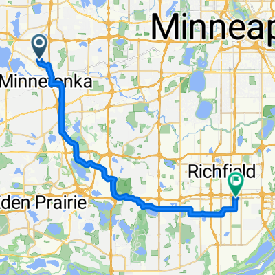
Route B2B 494/McGinty Bike path
A cycling route starting in Minnetonka Mills, Minnesota, United States.
Overview
About this route
Nice rolling bike path going from the Oakland rd bridge over 494 to Minnetonka blvd where you can catch the Northern LRT into Hopkins or go W to Victoria
- -:--
- Duration
- 3.2 km
- Distance
- 41 m
- Ascent
- 23 m
- Descent
- ---
- Avg. speed
- 308 m
- Max. altitude
Route quality
Waytypes & surfaces along the route
Waytypes
Cycleway
2.1 km
(66 %)
Busy road
0.7 km
(22 %)
Surfaces
Paved
1.4 km
(44 %)
Asphalt
0.8 km
(25 %)
Paved (undefined)
0.3 km
(11 %)
Continue with Bikemap
Use, edit, or download this cycling route
You would like to ride Route B2B 494/McGinty Bike path or customize it for your own trip? Here is what you can do with this Bikemap route:
Free features
- Save this route as favorite or in collections
- Copy & plan your own version of this route
- Sync your route with Garmin or Wahoo
Premium features
Free trial for 3 days, or one-time payment. More about Bikemap Premium.
- Navigate this route on iOS & Android
- Export a GPX / KML file of this route
- Create your custom printout (try it for free)
- Download this route for offline navigation
Discover more Premium features.
Get Bikemap PremiumFrom our community
Other popular routes starting in Minnetonka Mills
- Hopkins to University Hospital
- Distance
- 18.9 km
- Ascent
- 70 m
- Descent
- 90 m
- Location
- Minnetonka Mills, Minnesota, United States
- B2B00322 55305>55402 via Shady Oak Rd, Greenway, Cedar Lake Trl, S 10th St
- Distance
- 19.7 km
- Ascent
- 84 m
- Descent
- 125 m
- Location
- Minnetonka Mills, Minnesota, United States
- B2B00821 55426>55369 via Boone Av, Schmidt Lake Rd, Fish Lake Rd
- Distance
- 28.9 km
- Ascent
- 92 m
- Descent
- 86 m
- Location
- Minnetonka Mills, Minnesota, United States
- hopkins depot to arboretum loop
- Distance
- 56.1 km
- Ascent
- 163 m
- Descent
- 161 m
- Location
- Minnetonka Mills, Minnesota, United States
- B2B00825 55391>55420 via Baker, Rowland, 84th
- Distance
- 27.1 km
- Ascent
- 197 m
- Descent
- 233 m
- Location
- Minnetonka Mills, Minnesota, United States
- North Nine-mile Creek Trail
- Distance
- 10.4 km
- Ascent
- 414 m
- Descent
- 428 m
- Location
- Minnetonka Mills, Minnesota, United States
- B2B 55343 < 55415 via Kenilworth Trail, Hennepin Ave
- Distance
- 15.5 km
- Ascent
- 86 m
- Descent
- 98 m
- Location
- Minnetonka Mills, Minnesota, United States
- Hopkins Wayzata
- Distance
- 98.7 km
- Ascent
- 216 m
- Descent
- 218 m
- Location
- Minnetonka Mills, Minnesota, United States
Open it in the app