

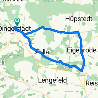
Unstrutradweg
A cycling route starting in Dingelstädt, Thuringia, Germany.
Overview
About this route
rr
- -:--
- Duration
- 146.6 km
- Distance
- 110 m
- Ascent
- 358 m
- Descent
- ---
- Avg. speed
- ---
- Max. altitude
Route quality
Waytypes & surfaces along the route
Waytypes
Quiet road
39.4 km
(27 %)
Track
36.5 km
(25 %)
Surfaces
Paved
122.6 km
(84 %)
Unpaved
11.2 km
(8 %)
Asphalt
113.4 km
(77 %)
Gravel
9.3 km
(6 %)
Route highlights
Points of interest along the route
Point of interest after 51.7 km
1. Übernachtung
Point of interest after 134.8 km
Continue with Bikemap
Use, edit, or download this cycling route
You would like to ride Unstrutradweg or customize it for your own trip? Here is what you can do with this Bikemap route:
Free features
- Save this route as favorite or in collections
- Copy & plan your own version of this route
- Split it into stages to create a multi-day tour
- Sync your route with Garmin or Wahoo
Premium features
Free trial for 3 days, or one-time payment. More about Bikemap Premium.
- Navigate this route on iOS & Android
- Export a GPX / KML file of this route
- Create your custom printout (try it for free)
- Download this route for offline navigation
Discover more Premium features.
Get Bikemap PremiumFrom our community
Other popular routes starting in Dingelstädt
 Unstrut-Werra-Runde
- Distance
- 88.2 km
- Ascent
- 596 m
- Descent
- 596 m
- Location
- Dingelstädt, Thuringia, Germany
 Dingelstädt - Bad Langensalza - Wiegleben
- Distance
- 52.8 km
- Ascent
- 259 m
- Descent
- 281 m
- Location
- Dingelstädt, Thuringia, Germany
 Kanonenbahnradweg
- Distance
- 42.1 km
- Ascent
- 418 m
- Descent
- 419 m
- Location
- Dingelstädt, Thuringia, Germany
 27.07 25 kleine mittags runde
- Distance
- 18.2 km
- Ascent
- 185 m
- Descent
- 225 m
- Location
- Dingelstädt, Thuringia, Germany
 Unstrutradweg
- Distance
- 146.6 km
- Ascent
- 110 m
- Descent
- 358 m
- Location
- Dingelstädt, Thuringia, Germany
 Dingelstädt-Heyerode-BadSooden
- Distance
- 91.5 km
- Ascent
- 331 m
- Descent
- 512 m
- Location
- Dingelstädt, Thuringia, Germany
 1.Silberhausen Keffernhausen Unstrutquelle
- Distance
- 5.9 km
- Ascent
- 94 m
- Descent
- 53 m
- Location
- Dingelstädt, Thuringia, Germany
 Trainingsrunde 3
- Distance
- 26.9 km
- Ascent
- 315 m
- Descent
- 311 m
- Location
- Dingelstädt, Thuringia, Germany
Open it in the app