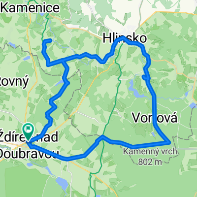
Oudolení No 1.
A cycling route starting in Krucemburk, Kraj Vysočina, Czechia.
Overview
About this route
Pohodový trip vhodný spíše pro trekking...
- -:--
- Duration
- 76 km
- Distance
- 571 m
- Ascent
- 571 m
- Descent
- ---
- Avg. speed
- ---
- Max. altitude
Route highlights
Points of interest along the route
Photo after 11.4 km
Památník u Žižkova pole.
Photo after 38.6 km
...way...
Photo after 46.6 km
Zámek Kinských.
Photo after 47.3 km
v.nádrž Pilská
Photo after 50.6 km
...roubenka a dokonce s doškama...to už jsem dlouho neviděl!
Continue with Bikemap
Use, edit, or download this cycling route
You would like to ride Oudolení No 1. or customize it for your own trip? Here is what you can do with this Bikemap route:
Free features
- Save this route as favorite or in collections
- Copy & plan your own version of this route
- Sync your route with Garmin or Wahoo
Premium features
Free trial for 3 days, or one-time payment. More about Bikemap Premium.
- Navigate this route on iOS & Android
- Export a GPX / KML file of this route
- Create your custom printout (try it for free)
- Download this route for offline navigation
Discover more Premium features.
Get Bikemap PremiumFrom our community
Other popular routes starting in Krucemburk
- Třemošnice tam a zpět
- Distance
- 62.1 km
- Ascent
- 474 m
- Descent
- 514 m
- Location
- Krucemburk, Kraj Vysočina, Czechia
- 2017-08-05 Řeka - lesem na Ranská jezírka-po modré Sobíńov-Bílek- dolní Sokolovec-Sloupno- Slavíkov-Možděnice-zubří- TK-Petrkov- Veselý k. Januš-Kohoutov
- Distance
- 56.1 km
- Ascent
- 548 m
- Descent
- 550 m
- Location
- Krucemburk, Kraj Vysočina, Czechia
- DoMi 1
- Distance
- 35.2 km
- Ascent
- 304 m
- Descent
- 307 m
- Location
- Krucemburk, Kraj Vysočina, Czechia
- Oudolení No 1.
- Distance
- 76 km
- Ascent
- 571 m
- Descent
- 571 m
- Location
- Krucemburk, Kraj Vysočina, Czechia
- 2012 06 13 Křížem krážem lesem nad Řekou
- Distance
- 24.9 km
- Ascent
- 209 m
- Descent
- 209 m
- Location
- Krucemburk, Kraj Vysočina, Czechia
- Oudolení No 2.
- Distance
- 37.6 km
- Ascent
- 424 m
- Descent
- 395 m
- Location
- Krucemburk, Kraj Vysočina, Czechia
- Ždírec nad Doubravou - Žďár nad Sázavou, pěšky
- Distance
- 21.9 km
- Ascent
- 263 m
- Descent
- 249 m
- Location
- Krucemburk, Kraj Vysočina, Czechia
- 2017-08-06 Řeka- Kohoutov-Stružinec- Údavy-Rovný- Podmokl-Štěpánov- po žluté- Bílek- Řeka
- Distance
- 33 km
- Ascent
- 328 m
- Descent
- 331 m
- Location
- Krucemburk, Kraj Vysočina, Czechia
Open it in the app