

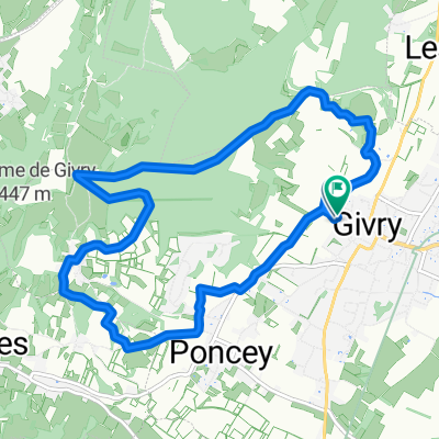
Givry - Cluny
A cycling route starting in Givry, Bourgogne-Franche-Comté, France.
Overview
About this route
Burgundy
- -:--
- Duration
- 44.2 km
- Distance
- 216 m
- Ascent
- 191 m
- Descent
- ---
- Avg. speed
- ---
- Max. altitude

Route quality
Waytypes & surfaces along the route
Waytypes
Quiet road
5.8 km
(13 %)
Track
1.8 km
(4 %)
Surfaces
Paved
18.1 km
(41 %)
Asphalt
18.1 km
(41 %)
Undefined
26.1 km
(59 %)
Continue with Bikemap
Use, edit, or download this cycling route
You would like to ride Givry - Cluny or customize it for your own trip? Here is what you can do with this Bikemap route:
Free features
- Save this route as favorite or in collections
- Copy & plan your own version of this route
- Sync your route with Garmin or Wahoo
Premium features
Free trial for 3 days, or one-time payment. More about Bikemap Premium.
- Navigate this route on iOS & Android
- Export a GPX / KML file of this route
- Create your custom printout (try it for free)
- Download this route for offline navigation
Discover more Premium features.
Get Bikemap PremiumFrom our community
Other popular routes starting in Givry
 De Chemin du Charollois 1, Givry à Chemin du Charollois 1, Givry
- Distance
- 9.9 km
- Ascent
- 230 m
- Descent
- 227 m
- Location
- Givry, Bourgogne-Franche-Comté, France
 Givry - Cluny
- Distance
- 44.2 km
- Ascent
- 216 m
- Descent
- 191 m
- Location
- Givry, Bourgogne-Franche-Comté, France
 VL - Châlon - Macon
- Distance
- 146.1 km
- Ascent
- 333 m
- Descent
- 332 m
- Location
- Givry, Bourgogne-Franche-Comté, France
 sortie 3 nov à givry
- Distance
- 10.8 km
- Ascent
- 237 m
- Descent
- 235 m
- Location
- Givry, Bourgogne-Franche-Comté, France
 T3_givry-santenay-beaune-nolay-givry
- Distance
- 84 km
- Ascent
- 601 m
- Descent
- 601 m
- Location
- Givry, Bourgogne-Franche-Comté, France
 5 Rue des Rocheriaux, Saint-Désert à 20 Rue du Dr Jeannin, Saint-Marcel
- Distance
- 29.2 km
- Ascent
- 1,841 m
- Descent
- 1,915 m
- Location
- Givry, Bourgogne-Franche-Comté, France
 Cormatin Givry par la Voie Verte Givry Puligny par la route
- Distance
- 29.2 km
- Ascent
- 296 m
- Descent
- 289 m
- Location
- Givry, Bourgogne-Franche-Comté, France
 Givry_Tournus
- Distance
- 40.4 km
- Ascent
- 98 m
- Descent
- 87 m
- Location
- Givry, Bourgogne-Franche-Comté, France
Open it in the app