- 97.3 km
- 1,671 m
- 2,915 m
- Hinterrhein, Grisons, Switzerland
Alpok bringatúra: 7. nap: Splügen – Rofaschlucht – Juf előtt... (.2050m) – Rofaschlucht – Thusis (723 m) – Solis – Stierva – Alp Stierva (2145 m) – Mon – Tiefen
A cycling route starting in Hinterrhein, Grisons, Switzerland.
Overview
About this route
Splügen – Rofas Gorge – before Juf (2050 m) – Rofas Gorge – Thusis (723 m) – Solis – Stierva – Alp Stierva (2145 m) – Mon – Tiefencastel – Thusis = 130.6 km + 2949 m elevation gain
- -:--
- Duration
- 126 km
- Distance
- 2,695 m
- Ascent
- 3,486 m
- Descent
- ---
- Avg. speed
- ---
- Max. altitude
created this 11 years ago
Route quality
Waytypes & surfaces along the route
Waytypes
Road
50.4 km
(40 %)
Track
25.2 km
(20 %)
Surfaces
Paved
105.8 km
(84 %)
Unpaved
16.4 km
(13 %)
Asphalt
99.5 km
(79 %)
Gravel
11.3 km
(9 %)
Continue with Bikemap
Use, edit, or download this cycling route
You would like to ride Alpok bringatúra: 7. nap: Splügen – Rofaschlucht – Juf előtt... (.2050m) – Rofaschlucht – Thusis (723 m) – Solis – Stierva – Alp Stierva (2145 m) – Mon – Tiefen or customize it for your own trip? Here is what you can do with this Bikemap route:
Free features
- Save this route as favorite or in collections
- Copy & plan your own version of this route
- Split it into stages to create a multi-day tour
- Sync your route with Garmin or Wahoo
Premium features
Free trial for 3 days, or one-time payment. More about Bikemap Premium.
- Navigate this route on iOS & Android
- Export a GPX / KML file of this route
- Create your custom printout (try it for free)
- Download this route for offline navigation
Discover more Premium features.
Get Bikemap PremiumFrom our community
Other popular routes starting in Hinterrhein
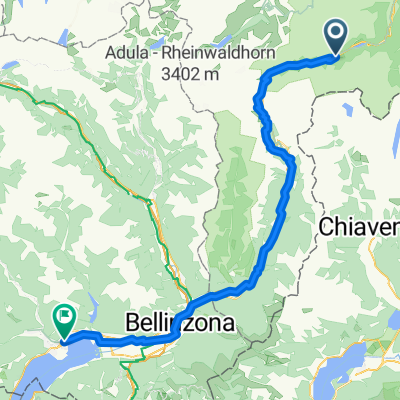
- Splugen, Mesocco, Locarno
- Tag 1: Von Splügen nach Chiavenna
- 39.2 km
- 683 m
- 1,811 m
- Hinterrhein, Grisons, Switzerland
- San Bernadino Maccagno
- 79.7 km
- 164 m
- 1,556 m
- Hinterrhein, Grisons, Switzerland
- Von Madesimo bis Ischgl
- 195.9 km
- 3,626 m
- 4,358 m
- Hinterrhein, Grisons, Switzerland
- Giro a velocità lenta in Splügen
- 16 km
- 519 m
- 518 m
- Hinterrhein, Grisons, Switzerland
- Strada del Pass, S. Bernardino nach Unterdorfstrasse, Igis
- 93.1 km
- 2,949 m
- 4,059 m
- Hinterrhein, Grisons, Switzerland
- Poststrasse to Via Cantonale
- 65.1 km
- 1,641 m
- 2,714 m
- Hinterrhein, Grisons, Switzerland
- St. Bernardiopass - Thusis
- 45.9 km
- 241 m
- 1,613 m
- Hinterrhein, Grisons, Switzerland
Open it in the app


