

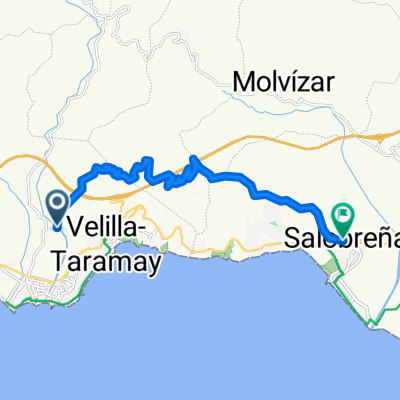
Velilla - Adra
A cycling route starting in Almuñécar, Andalusia, Spain.
Overview
About this route
From Velilla to Adra following the old N-340
- -:--
- Duration
- 71.2 km
- Distance
- 773 m
- Ascent
- 772 m
- Descent
- ---
- Avg. speed
- ---
- Max. altitude
Continue with Bikemap
Use, edit, or download this cycling route
You would like to ride Velilla - Adra or customize it for your own trip? Here is what you can do with this Bikemap route:
Free features
- Save this route as favorite or in collections
- Copy & plan your own version of this route
- Sync your route with Garmin or Wahoo
Premium features
Free trial for 3 days, or one-time payment. More about Bikemap Premium.
- Navigate this route on iOS & Android
- Export a GPX / KML file of this route
- Create your custom printout (try it for free)
- Download this route for offline navigation
Discover more Premium features.
Get Bikemap PremiumFrom our community
Other popular routes starting in Almuñécar
 Andalucía con alforjas. +/- 7000m en 800km
- Distance
- 795.5 km
- Ascent
- 9,571 m
- Descent
- 9,570 m
- Location
- Almuñécar, Andalusia, Spain
 Velilla - Adra
- Distance
- 71.2 km
- Ascent
- 773 m
- Descent
- 772 m
- Location
- Almuñécar, Andalusia, Spain
 Almuñecar - Carretera de la Cabra
- Distance
- 69.5 km
- Ascent
- 1,845 m
- Descent
- 1,842 m
- Location
- Almuñécar, Andalusia, Spain
 Paseo de Cotobro, 9, Almuñécar nach Calle del Barranco de Cotobro, 2, Almuñécar
- Distance
- 7.7 km
- Ascent
- 128 m
- Descent
- 119 m
- Location
- Almuñécar, Andalusia, Spain
 Aluñécar Subida a la Cabra
- Distance
- 33.3 km
- Ascent
- 1,463 m
- Descent
- 215 m
- Location
- Almuñécar, Andalusia, Spain
 Las 7 cuestas: Almuñecar
- Distance
- 30.5 km
- Ascent
- 716 m
- Descent
- 721 m
- Location
- Almuñécar, Andalusia, Spain
 Almuñécar - Salobreña
- Distance
- 15.8 km
- Ascent
- 908 m
- Descent
- 911 m
- Location
- Almuñécar, Andalusia, Spain
 alt for lang t/r
- Distance
- 110.6 km
- Ascent
- 1,728 m
- Descent
- 1,734 m
- Location
- Almuñécar, Andalusia, Spain
Open it in the app