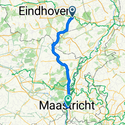
Ommel-Asten en omgev.gpx
A cycling route starting in Asten, North Brabant, The Netherlands.
Overview
About this route
TEASI Track
- -:--
- Duration
- 61 km
- Distance
- 39 m
- Ascent
- 41 m
- Descent
- ---
- Avg. speed
- ---
- Max. altitude
Route quality
Waytypes & surfaces along the route
Waytypes
Quiet road
40.2 km
(66 %)
Cycleway
12.2 km
(20 %)
Surfaces
Paved
18.9 km
(31 %)
Unpaved
4.9 km
(8 %)
Asphalt
17.1 km
(28 %)
Gravel
3.7 km
(6 %)
Route highlights
Points of interest along the route
Point of interest after 18 km
DE GROOTE PEEL
Continue with Bikemap
Use, edit, or download this cycling route
You would like to ride Ommel-Asten en omgev.gpx or customize it for your own trip? Here is what you can do with this Bikemap route:
Free features
- Save this route as favorite or in collections
- Copy & plan your own version of this route
- Sync your route with Garmin or Wahoo
Premium features
Free trial for 3 days, or one-time payment. More about Bikemap Premium.
- Navigate this route on iOS & Android
- Export a GPX / KML file of this route
- Create your custom printout (try it for free)
- Download this route for offline navigation
Discover more Premium features.
Get Bikemap PremiumFrom our community
Other popular routes starting in Asten
- Ommel-Asten en omgev.gpx
- Distance
- 61 km
- Ascent
- 39 m
- Descent
- 41 m
- Location
- Asten, North Brabant, The Netherlands
- B&amp
- Distance
- 43.1 km
- Ascent
- 12 m
- Descent
- 12 m
- Location
- Asten, North Brabant, The Netherlands
- Deurne 33 km
- Distance
- 33.5 km
- Ascent
- 22 m
- Descent
- 23 m
- Location
- Asten, North Brabant, The Netherlands
- Liesels bos
- Distance
- 14.3 km
- Ascent
- 17 m
- Descent
- 17 m
- Location
- Asten, North Brabant, The Netherlands
- ast-schuteb-deu-ast
- Distance
- 34.5 km
- Ascent
- 25 m
- Descent
- 24 m
- Location
- Asten, North Brabant, The Netherlands
- Peel & Maas
- Distance
- 125 km
- Ascent
- 263 m
- Descent
- 266 m
- Location
- Asten, North Brabant, The Netherlands
- Start
- Distance
- 0.1 km
- Ascent
- 0 m
- Descent
- 0 m
- Location
- Asten, North Brabant, The Netherlands
- Rond Eindhoven
- Distance
- 104.3 km
- Ascent
- 51 m
- Descent
- 52 m
- Location
- Asten, North Brabant, The Netherlands
Open it in the app