

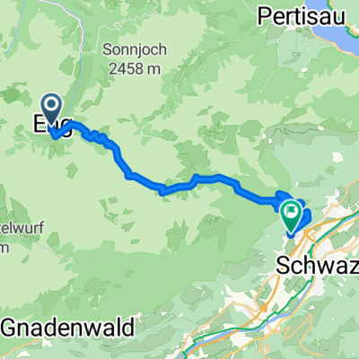
Engalm - Lamsensattel - Fiecht
A cycling route starting in Gnadenwald, Tyrol, Austria.
Overview
About this route
From Engalm at the Great Ahornboden, partly on rideable paths, partly pushing over the Lamsensattel to Fiecht near Schwaz.
- -:--
- Duration
- 20 km
- Distance
- 805 m
- Ascent
- 1,419 m
- Descent
- ---
- Avg. speed
- ---
- Max. altitude

Route highlights
Points of interest along the route
Point of interest after 0.7 km
Großer Ahornboden
Point of interest after 2.3 km
Binsalm
Point of interest after 6.3 km
Lampsenjochhütte
Point of interest after 10.5 km
Stallenalm
Continue with Bikemap
Use, edit, or download this cycling route
You would like to ride Engalm - Lamsensattel - Fiecht or customize it for your own trip? Here is what you can do with this Bikemap route:
Free features
- Save this route as favorite or in collections
- Copy & plan your own version of this route
- Sync your route with Garmin or Wahoo
Premium features
Free trial for 3 days, or one-time payment. More about Bikemap Premium.
- Navigate this route on iOS & Android
- Export a GPX / KML file of this route
- Create your custom printout (try it for free)
- Download this route for offline navigation
Discover more Premium features.
Get Bikemap PremiumFrom our community
Other popular routes starting in Gnadenwald
 Gnadenwald Rumer Alm
- Distance
- 25.4 km
- Ascent
- 614 m
- Descent
- 432 m
- Location
- Gnadenwald, Tyrol, Austria
 Walderalm / Hinterhornalm
- Distance
- 23.8 km
- Ascent
- 713 m
- Descent
- 715 m
- Location
- Gnadenwald, Tyrol, Austria
 rund wachensee and wally
- Distance
- 136.7 km
- Ascent
- 638 m
- Descent
- 1,216 m
- Location
- Gnadenwald, Tyrol, Austria
 Von Hinteriss zur Falkenhütte
- Distance
- 33.7 km
- Ascent
- 1,013 m
- Descent
- 1,013 m
- Location
- Gnadenwald, Tyrol, Austria
 3. Tag: Falken Engalm Plumsjoch Pertisau
- Distance
- 21.8 km
- Ascent
- 866 m
- Descent
- 1,434 m
- Location
- Gnadenwald, Tyrol, Austria
 Gnadenwald Innsbruck und retour
- Distance
- 36.5 km
- Ascent
- 495 m
- Descent
- 495 m
- Location
- Gnadenwald, Tyrol, Austria
 Wallgau-Eng Alm
- Distance
- 37.4 km
- Ascent
- 172 m
- Descent
- 520 m
- Location
- Gnadenwald, Tyrol, Austria
 Engalm - Lamsensattel - Fiecht
- Distance
- 20 km
- Ascent
- 805 m
- Descent
- 1,419 m
- Location
- Gnadenwald, Tyrol, Austria
Open it in the app