

grunerunde
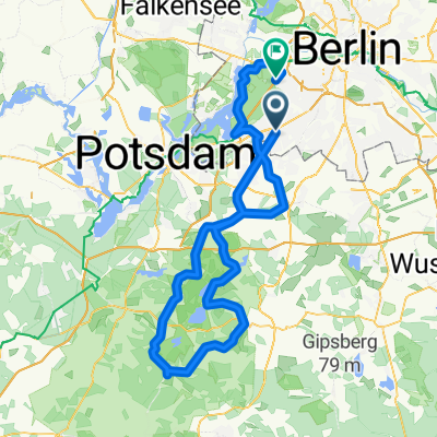
A cycling route starting in Zehlendorf, State of Berlin, Germany.
Overview
About this route
- -:--
- Duration
- 31.4 km
- Distance
- 181 m
- Ascent
- 178 m
- Descent
- ---
- Avg. speed
- 83 m
- Max. altitude
Route quality
Waytypes & surfaces along the route
Waytypes
Quiet road
13.7 km
(43 %)
Road
10 km
(32 %)
Surfaces
Paved
31.4 km
(100 %)
Asphalt
29.9 km
(95 %)
Paving stones
1.1 km
(3 %)
Continue with Bikemap
Use, edit, or download this cycling route
You would like to ride grunerunde or customize it for your own trip? Here is what you can do with this Bikemap route:
Free features
- Save this route as favorite or in collections
- Copy & plan your own version of this route
- Sync your route with Garmin or Wahoo
Premium features
Free trial for 3 days, or one-time payment. More about Bikemap Premium.
- Navigate this route on iOS & Android
- Export a GPX / KML file of this route
- Create your custom printout (try it for free)
- Download this route for offline navigation
Discover more Premium features.
Get Bikemap PremiumFrom our community
Other popular routes starting in Zehlendorf
 S Zehlendorf -> Tremsdorf -> Caputh -> Auerbachtunnel
- Distance
- 65.4 km
- Ascent
- 258 m
- Descent
- 245 m
- Location
- Zehlendorf, State of Berlin, Germany
 Dahlem Route
- Distance
- 15.8 km
- Ascent
- 49 m
- Descent
- 52 m
- Location
- Zehlendorf, State of Berlin, Germany
 Zehlendorf -> Trebbin
- Distance
- 72.6 km
- Ascent
- 96 m
- Descent
- 95 m
- Location
- Zehlendorf, State of Berlin, Germany
 Berliner Mauerweg
- Distance
- 172.8 km
- Ascent
- 175 m
- Descent
- 181 m
- Location
- Zehlendorf, State of Berlin, Germany
 Radtour Südlich von Berlin
- Distance
- 68.2 km
- Ascent
- 117 m
- Descent
- 117 m
- Location
- Zehlendorf, State of Berlin, Germany
 Zehlendorf -> Fresdorf -> Caputh -> Teufelsberg
- Distance
- 85.4 km
- Ascent
- 298 m
- Descent
- 287 m
- Location
- Zehlendorf, State of Berlin, Germany
 Dobbrikow andersrum
- Distance
- 111.2 km
- Ascent
- 139 m
- Descent
- 133 m
- Location
- Zehlendorf, State of Berlin, Germany
 Grunewaldrund
- Distance
- 25.9 km
- Ascent
- 305 m
- Descent
- 301 m
- Location
- Zehlendorf, State of Berlin, Germany
Open it in the app