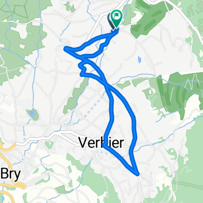
Above Verbier
A cycling route starting in Verbier, Valais, Switzerland.
Overview
About this route
great mountain bike ride above Verbier. Â High point is Col de Chassoure at 2739 metres. Â The cliff road after col des mines is incredible.Â
- -:--
- Duration
- 34.5 km
- Distance
- 1,191 m
- Ascent
- 1,172 m
- Descent
- ---
- Avg. speed
- ---
- Avg. speed
Route highlights
Points of interest along the route
Point of interest after 7.4 km
Croix de Couer
Point of interest after 11.3 km
Col des Mines
Point of interest after 13.7 km
LAC DES VAUX
Point of interest after 15 km
Col des Vaux
Point of interest after 16 km
Col de Chassoure
Continue with Bikemap
Use, edit, or download this cycling route
You would like to ride Above Verbier or customize it for your own trip? Here is what you can do with this Bikemap route:
Free features
- Save this route as favorite or in collections
- Copy & plan your own version of this route
- Sync your route with Garmin or Wahoo
Premium features
Free trial for 3 days, or one-time payment. More about Bikemap Premium.
- Navigate this route on iOS & Android
- Export a GPX / KML file of this route
- Create your custom printout (try it for free)
- Download this route for offline navigation
Discover more Premium features.
Get Bikemap PremiumFrom our community
Other popular routes starting in Verbier
- Verbier Early summer route
- Distance
- 15.9 km
- Ascent
- 945 m
- Descent
- 945 m
- Location
- Verbier, Valais, Switzerland
- Grand Raid Verbier - Grimentz 2009
- Distance
- 114.4 km
- Ascent
- 3,947 m
- Descent
- 3,853 m
- Location
- Verbier, Valais, Switzerland
- testrunde 2 Verbier
- Distance
- 3.8 km
- Ascent
- 123 m
- Descent
- 120 m
- Location
- Verbier, Valais, Switzerland
- Tag 2 Verbier-Mauvoisin
- Distance
- 71.5 km
- Ascent
- 2,644 m
- Descent
- 2,416 m
- Location
- Verbier, Valais, Switzerland
- Verbier -Megeve
- Distance
- 105.1 km
- Ascent
- 1,843 m
- Descent
- 2,163 m
- Location
- Verbier, Valais, Switzerland
- De Rue de Ransou 72, Bagnes à Rue de Ransou 72, Bagnes
- Distance
- 132 km
- Ascent
- 2,810 m
- Descent
- 2,812 m
- Location
- Verbier, Valais, Switzerland
- V2V - D1
- Distance
- 152.1 km
- Ascent
- 2,637 m
- Descent
- 3,557 m
- Location
- Verbier, Valais, Switzerland
- Verbier to the Chanrion Hut
- Distance
- 73.4 km
- Ascent
- 2,319 m
- Descent
- 2,319 m
- Location
- Verbier, Valais, Switzerland
Open it in the app