
Kurešček
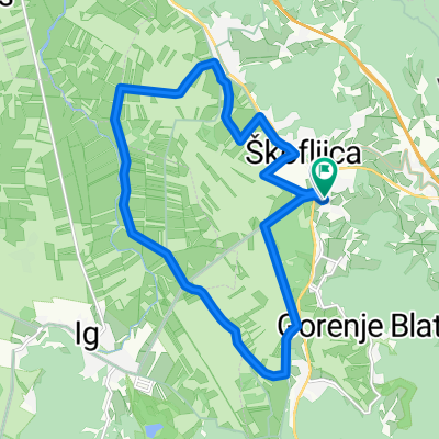
A cycling route starting in Škofljica, Občina Škofljica, Slovenia.
Overview
About this route
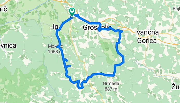
Škofljica - Ig - Kurešček - Rašica - Zdenaska vas - Ilova gora - Višna gora - Šmarje Sap
- -:--
- Duration
- 73.7 km
- Distance
- 912 m
- Ascent
- 912 m
- Descent
- ---
- Avg. speed
- ---
- Max. altitude
Route quality
Waytypes & surfaces along the route
Waytypes
Road
30.2 km
(41 %)
Quiet road
28.8 km
(39 %)
Surfaces
Paved
59.7 km
(81 %)
Asphalt
52.3 km
(71 %)
Paved (undefined)
7.4 km
(10 %)
Undefined
14 km
(19 %)
Continue with Bikemap
Use, edit, or download this cycling route
You would like to ride Kurešček or customize it for your own trip? Here is what you can do with this Bikemap route:
Free features
- Save this route as favorite or in collections
- Copy & plan your own version of this route
- Sync your route with Garmin or Wahoo
Premium features
Free trial for 3 days, or one-time payment. More about Bikemap Premium.
- Navigate this route on iOS & Android
- Export a GPX / KML file of this route
- Create your custom printout (try it for free)
- Download this route for offline navigation
Discover more Premium features.
Get Bikemap PremiumFrom our community
Other popular routes starting in Škofljica
 Lj barje
- Distance
- 41.2 km
- Ascent
- 44 m
- Descent
- 49 m
- Location
- Škofljica, Občina Škofljica, Slovenia
 Škofljica-Ig-Turjak-Grosuplje-Šk
- Distance
- 48.2 km
- Ascent
- 365 m
- Descent
- 360 m
- Location
- Škofljica, Občina Škofljica, Slovenia
 Škofljica - Turjak - Škofljica
- Distance
- 55.8 km
- Ascent
- 1,221 m
- Descent
- 1,223 m
- Location
- Škofljica, Občina Škofljica, Slovenia
 kolesarska družinska pot Škofljica-Lavrica
- Distance
- 13.4 km
- Ascent
- 48 m
- Descent
- 34 m
- Location
- Škofljica, Občina Škofljica, Slovenia
 Pot na Rašico
- Distance
- 39.5 km
- Ascent
- 446 m
- Descent
- 446 m
- Location
- Škofljica, Občina Škofljica, Slovenia
 Družinska kolesarska pot po Škofljici
- Distance
- 15.8 km
- Ascent
- 52 m
- Descent
- 49 m
- Location
- Škofljica, Občina Škofljica, Slovenia
 Šk-turjak-grosuplje-šk
- Distance
- 40.3 km
- Ascent
- 340 m
- Descent
- 397 m
- Location
- Škofljica, Občina Škofljica, Slovenia
 Kurešček
- Distance
- 73.7 km
- Ascent
- 912 m
- Descent
- 912 m
- Location
- Škofljica, Občina Škofljica, Slovenia
Open it in the app