

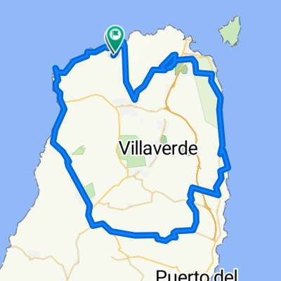
RUTA DE PISTA POR NORTE FUERTEVENTURA
A cycling route starting in El Cotillo, Canary Islands, Spain.
Overview
About this route
Circular route from Lajares, Corralejo, Cotillo to Tindaya
- -:--
- Duration
- 79.2 km
- Distance
- 576 m
- Ascent
- 574 m
- Descent
- ---
- Avg. speed
- ---
- Max. altitude
Route quality
Waytypes & surfaces along the route
Waytypes
Track
57 km
(72 %)
Quiet road
17.4 km
(22 %)
Surfaces
Paved
6.3 km
(8 %)
Unpaved
59.4 km
(75 %)
Gravel
41.2 km
(52 %)
Ground
17.4 km
(22 %)
Continue with Bikemap
Use, edit, or download this cycling route
You would like to ride RUTA DE PISTA POR NORTE FUERTEVENTURA or customize it for your own trip? Here is what you can do with this Bikemap route:
Free features
- Save this route as favorite or in collections
- Copy & plan your own version of this route
- Sync your route with Garmin or Wahoo
Premium features
Free trial for 3 days, or one-time payment. More about Bikemap Premium.
- Navigate this route on iOS & Android
- Export a GPX / KML file of this route
- Create your custom printout (try it for free)
- Download this route for offline navigation
Discover more Premium features.
Get Bikemap PremiumFrom our community
Other popular routes starting in El Cotillo
 Fuerteventura 2
- Distance
- 50 km
- Ascent
- 403 m
- Descent
- 403 m
- Location
- El Cotillo, Canary Islands, Spain
 Calle del Coronel González del Yerro, 2, La Oliva naar Calle Majanicho, La Oliva
- Distance
- 6.8 km
- Ascent
- 52 m
- Descent
- 105 m
- Location
- El Cotillo, Canary Islands, Spain
 Vía Sin Nombre, La Oliva nach ኡርባኒሳሲኦን ኦሪጎ ማሬ, La Oliva
- Distance
- 96.1 km
- Ascent
- 1,341 m
- Descent
- 1,341 m
- Location
- El Cotillo, Canary Islands, Spain
 RUTA DE PISTA POR NORTE FUERTEVENTURA
- Distance
- 79.2 km
- Ascent
- 576 m
- Descent
- 574 m
- Location
- El Cotillo, Canary Islands, Spain
 createTest1
- Distance
- 46.5 km
- Ascent
- 357 m
- Descent
- 363 m
- Location
- El Cotillo, Canary Islands, Spain
 Betancuria
- Distance
- 125.9 km
- Ascent
- 1,101 m
- Descent
- 1,102 m
- Location
- El Cotillo, Canary Islands, Spain
 Route nach Calle Majanicho, 35650 La Oliva
- Distance
- 91.7 km
- Ascent
- 1,152 m
- Descent
- 1,152 m
- Location
- El Cotillo, Canary Islands, Spain
 Easy ride in La Oliva
- Distance
- 0.1 km
- Ascent
- 0 m
- Descent
- 0 m
- Location
- El Cotillo, Canary Islands, Spain
Open it in the app