
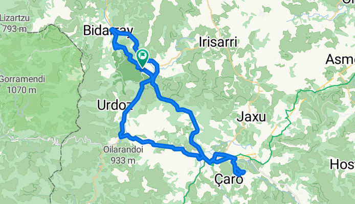
2014 Ride Day 80 - St-Martin-d’Arrossa Circle through Bidarry, Ossés, St-Jean-Pied-de-Port, Lac d’Harrieta, SJPdP, and St-Étienne-de-Baïgorry
A cycling route starting in Saint-Étienne-de-Baïgorry, Nouvelle-Aquitaine, France.
Overview
About this route
<div style="color: rgb(0, 0, 0); font-family: Helvetica; font-size: 18px;"> <span style="color: rgb(17, 5, 59); font-family: ProximaNovaSoft-Regular, Helvetica, 'Helvetica Neue', sans-serif;">Great ride with some very steep sections up and down during the first 10 kilometers or so. These sections were well paved former goat paths. Some very beautiful views. The rest is on excellent roads that are either low-traffic or have excellent shoulder.</span></div> <div style="color: rgb(0, 0, 0); font-family: Helvetica; font-size: 18px;"> </div> <div style="color: rgb(0, 0, 0); font-family: Helvetica; font-size: 18px;"> <font color="#11053b" face="ProximaNovaSoft-Regular, Helvetica, Helvetica Neue, sans-serif">The ride was actually a circle from l’Harrieta, but in order for the map to show up by the steep section, I started and ended the ride at </font>St-Martin-d’Arrossa.</div>
- -:--
- Duration
- 54.1 km
- Distance
- 536 m
- Ascent
- 536 m
- Descent
- ---
- Avg. speed
- ---
- Max. altitude

Route quality
Waytypes & surfaces along the route
Waytypes
Quiet road
15.7 km
(29 %)
Road
1.6 km
(3 %)
Surfaces
Paved
26 km
(48 %)
Asphalt
26 km
(48 %)
Undefined
28.1 km
(52 %)
Continue with Bikemap
Use, edit, or download this cycling route
You would like to ride 2014 Ride Day 80 - St-Martin-d’Arrossa Circle through Bidarry, Ossés, St-Jean-Pied-de-Port, Lac d’Harrieta, SJPdP, and St-Étienne-de-Baïgorry or customize it for your own trip? Here is what you can do with this Bikemap route:
Free features
- Save this route as favorite or in collections
- Copy & plan your own version of this route
- Sync your route with Garmin or Wahoo
Premium features
Free trial for 3 days, or one-time payment. More about Bikemap Premium.
- Navigate this route on iOS & Android
- Export a GPX / KML file of this route
- Create your custom printout (try it for free)
- Download this route for offline navigation
Discover more Premium features.
Get Bikemap PremiumFrom our community
Other popular routes starting in Saint-Étienne-de-Baïgorry
 Urepel - Lindux - Ibañeta
- Distance
- 16.5 km
- Ascent
- 1,065 m
- Descent
- 371 m
- Location
- Saint-Étienne-de-Baïgorry, Nouvelle-Aquitaine, France
 Bicitour2016-3
- Distance
- 84.9 km
- Ascent
- 1,781 m
- Descent
- 1,916 m
- Location
- Saint-Étienne-de-Baïgorry, Nouvelle-Aquitaine, France
 Aldudes - Ehunzaroy
- Distance
- 149.2 km
- Ascent
- 4,078 m
- Descent
- 3,469 m
- Location
- Saint-Étienne-de-Baïgorry, Nouvelle-Aquitaine, France
 D3PM_Long__BBIIR6A_Col_d_Izpegi
- Distance
- 8.1 km
- Ascent
- 538 m
- Descent
- 22 m
- Location
- Saint-Étienne-de-Baïgorry, Nouvelle-Aquitaine, France
 Col d'Ispeguy // CBPF
- Distance
- 44.6 km
- Ascent
- 765 m
- Descent
- 770 m
- Location
- Saint-Étienne-de-Baïgorry, Nouvelle-Aquitaine, France
 Urepel - Irouléguy
- Distance
- 42.3 km
- Ascent
- 1,241 m
- Descent
- 1,392 m
- Location
- Saint-Étienne-de-Baïgorry, Nouvelle-Aquitaine, France
 2014 Ride Day 80 - St-Martin-d’Arrossa Circle through Bidarry, Ossés, St-Jean-Pied-de-Port, Lac d’Harrieta, SJPdP, and St-Étienne-de-Baïgorry
- Distance
- 54.1 km
- Ascent
- 536 m
- Descent
- 536 m
- Location
- Saint-Étienne-de-Baïgorry, Nouvelle-Aquitaine, France
 Saint-Etienne-de-Baïgorry - Errozate
- Distance
- 101.5 km
- Ascent
- 4,610 m
- Descent
- 3,480 m
- Location
- Saint-Étienne-de-Baïgorry, Nouvelle-Aquitaine, France
Open it in the app