

Agazzano e dintorni
A cycling route starting in Agazzano, Emilia-Romagna, Italy.
Overview
About this route
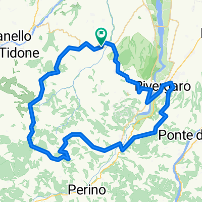
Agazzano Momeliano Pigazzano Monticello Guada Pomaro Piozzano Monte Canino
- -:--
- Duration
- 32.1 km
- Distance
- 754 m
- Ascent
- 754 m
- Descent
- ---
- Avg. speed
- ---
- Max. altitude

Route quality
Waytypes & surfaces along the route
Waytypes
Quiet road
12.8 km
(40 %)
Track
12.2 km
(38 %)
Surfaces
Paved
8.7 km
(27 %)
Unpaved
3.8 km
(12 %)
Asphalt
8.5 km
(27 %)
Gravel
1.8 km
(6 %)
Continue with Bikemap
Use, edit, or download this cycling route
You would like to ride Agazzano e dintorni or customize it for your own trip? Here is what you can do with this Bikemap route:
Free features
- Save this route as favorite or in collections
- Copy & plan your own version of this route
- Sync your route with Garmin or Wahoo
Premium features
Free trial for 3 days, or one-time payment. More about Bikemap Premium.
- Navigate this route on iOS & Android
- Export a GPX / KML file of this route
- Create your custom printout (try it for free)
- Download this route for offline navigation
Discover more Premium features.
Get Bikemap PremiumFrom our community
Other popular routes starting in Agazzano
 220820 Da Agazzano Val Luretta e Val Tidone
- Distance
- 56 km
- Ascent
- 1,020 m
- Descent
- 1,021 m
- Location
- Agazzano, Emilia-Romagna, Italy
 Agazzano e dintorni
- Distance
- 32.1 km
- Ascent
- 754 m
- Descent
- 754 m
- Location
- Agazzano, Emilia-Romagna, Italy
 Agazzano - Gambaro
- Distance
- 61.6 km
- Ascent
- 1,745 m
- Descent
- 1,065 m
- Location
- Agazzano, Emilia-Romagna, Italy
 giro nel piacentino seconda parte
- Distance
- 13.1 km
- Ascent
- 93 m
- Descent
- 164 m
- Location
- Agazzano, Emilia-Romagna, Italy
 Agazzano-Caldarola-Agazzano
- Distance
- 48.4 km
- Ascent
- 887 m
- Descent
- 883 m
- Location
- Agazzano, Emilia-Romagna, Italy
 Agazzano / Pomaro / Roccapulzana / Rocca d'Olgisio / Pianello / Strada del Cantone / Agazzano
- Distance
- 40.2 km
- Ascent
- 885 m
- Descent
- 888 m
- Location
- Agazzano, Emilia-Romagna, Italy
 Giro ottobrino
- Distance
- 78.1 km
- Ascent
- 1,324 m
- Descent
- 1,300 m
- Location
- Agazzano, Emilia-Romagna, Italy
 Agazzano Statto Riverg Rallio Travo Caldarola Montecanino Agazz
- Distance
- 58.8 km
- Ascent
- 1,044 m
- Descent
- 1,042 m
- Location
- Agazzano, Emilia-Romagna, Italy
Open it in the app