Europaroute D3 (D-Netz-Route 3)
A cycling route starting in Vreden, North Rhine-Westphalia, Germany.
Overview
About this route
The D-Netz-Route 3 is a long-distance cycling route spanning 960 kilometers from Vreden-Zwillbrock at the Dutch border to Küstrin-Kietz at the Polish border. The D-Netz-Route 3 is the German section of the EuroVelo R1 and the EuroVelo Route 'Capital Route' (EV2). Along the way across Germany, you'll encounter diverse landscapes and numerous cultural highlights. The route passes through the flat Münsterland, the hilly Weserbergland, the Harz foothills, and the vast Fläming region. The Oderbruch area and the river landscapes of the Weser, Saale, Elbe, plus a biosphere reserve lie along the route. Culturally, there are seven UNESCO World Heritage sites offering a lot, from Quedlinburg through Lutherstadt Wittenberg to Dessau. The route mostly runs close to nature and is largely car-free on separate paths or forest roads. The long-distance cycle path is partly unpaved.
The text and images used here are sourced from Wikipedia.
- -:--
- Duration
- 927.6 km
- Distance
- 1,077 m
- Ascent
- 1,099 m
- Descent
- ---
- Avg. speed
- ---
- Max. altitude
Route quality
Waytypes & surfaces along the route
Waytypes
Quiet road
296.8 km
(32 %)
Path
222.6 km
(24 %)
Surfaces
Paved
667.8 km
(72 %)
Unpaved
120.6 km
(13 %)
Asphalt
630.7 km
(68 %)
Gravel
102 km
(11 %)
Route highlights
Points of interest along the route

Point of interest after 109.1 km
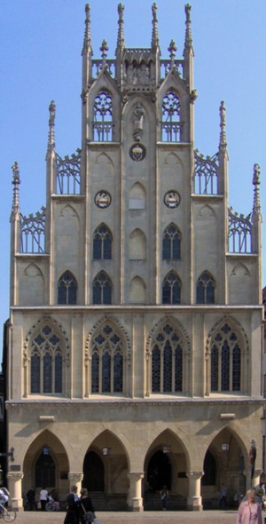
Historisches Rathaus Münster Das Historische Rathaus von Münster am Prinzipalmarkt ist neben dem St.-Paulus-Dom eines der Wahrzeichen der Stadt. Bekanntheit erlangte es während der Verhandlungen zum Westfälischen Frieden in Münster und Osnabrück, der den Dreißigjährigen Krieg in Europa beendete. Zug

Point of interest after 249.4 km
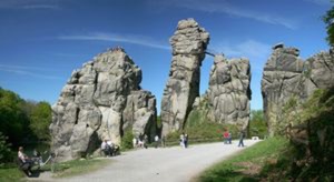
Externsteine Die Externsteine sind eine markante Sandstein-Felsformation im Teutoburger Wald und als solche eine herausragende Natursehenswürdigkeit Deutschlands. Innerhalb von Nordrhein-Westfalen im Kreis Lippe gelegen, gehören sie zu Horn-Bad Meinberg und sind von einer parkartigen Anlage umgeben.
Continue with Bikemap
Use, edit, or download this cycling route
You would like to ride Europaroute D3 (D-Netz-Route 3) or customize it for your own trip? Here is what you can do with this Bikemap route:
Free features
- Save this route as favorite or in collections
- Copy & plan your own version of this route
- Split it into stages to create a multi-day tour
- Sync your route with Garmin or Wahoo
Premium features
Free trial for 3 days, or one-time payment. More about Bikemap Premium.
- Navigate this route on iOS & Android
- Export a GPX / KML file of this route
- Create your custom printout (try it for free)
- Download this route for offline navigation
Discover more Premium features.
Get Bikemap PremiumFrom our community
Other popular routes starting in Vreden
 Europaroute D3 (D-Netz-Route 3)
- Distance
- 927.6 km
- Ascent
- 1,077 m
- Descent
- 1,099 m
- Location
- Vreden, North Rhine-Westphalia, Germany
 LH Vreden-Winterswijk-Cafe-Vreden_200504
- Distance
- 29.2 km
- Ascent
- 24 m
- Descent
- 27 m
- Location
- Vreden, North Rhine-Westphalia, Germany
 awv20-Vreden-Wüllen-Graes-Ottenstein-Vreden
- Distance
- 40.9 km
- Ascent
- 57 m
- Descent
- 56 m
- Location
- Vreden, North Rhine-Westphalia, Germany
 V047-Winterswijk-Korenburgerveen-47km
- Distance
- 46.8 km
- Ascent
- 48 m
- Descent
- 49 m
- Location
- Vreden, North Rhine-Westphalia, Germany
 H1-Hoogstede-87km
- Distance
- 86.7 km
- Ascent
- 168 m
- Descent
- 191 m
- Location
- Vreden, North Rhine-Westphalia, Germany
 awv11-Vredener Kirchdörfer
- Distance
- 45.8 km
- Ascent
- 50 m
- Descent
- 52 m
- Location
- Vreden, North Rhine-Westphalia, Germany
 Buursezandroute
- Distance
- 39.1 km
- Ascent
- 34 m
- Descent
- 34 m
- Location
- Vreden, North Rhine-Westphalia, Germany
 awv2-Vreden-Ammeloe-Witte Veen-Alstätte-Vreden
- Distance
- 49.9 km
- Ascent
- 62 m
- Descent
- 61 m
- Location
- Vreden, North Rhine-Westphalia, Germany
Open it in the app

